Fell Ponies and Conservation Grazing - 2

In Sue Millard’s book Hoofprints in Eden, Sue describes how Fell Ponies have historically fit into the grazing year of traditional hill farms. She points out that most fell farms are predominantly grass farms, without or with only a small amount of arable land. Fell rights, when they have them, allow the farmers to put their stock – sheep, cattle, ponies – out onto the common so that a hay crop for instance might be harvested from the close-in grounds. Or at least, by the stock being out on the fell, there’s lessened impact of the stock on the close-in ground during the growing season. (1)

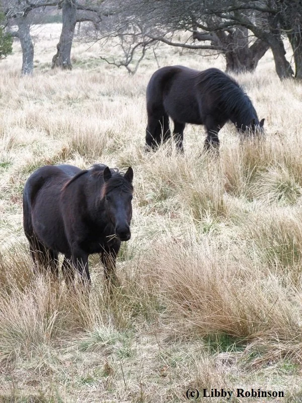
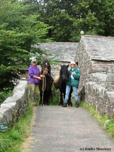
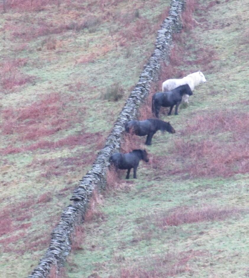
Two members of the Globetrotter Fell Pony herd help control rushes at Gowbarrow Hall Farm as part of a regenerative grazing program. Courtesy Libby Robinson

More recently, Fell Ponies have been used for conservation grazing: managed grazing to achieve a defined conservation benefit. For instance, in the winter of 2021, three Greenholme Fell Pony yearlings were used for a few months at Clints Quarry near Egremont, west of the Lake District, to improve habitat for wildflowers. Sarah Dalrymple, Reserves Officer for Cumbria Wildlife Trust, explains the role the ponies played: “The ponies have been brought here deliberately to graze on the vegetation. We want them to control the overgrown scrub, so that the fantastic wildflowers, which this quarry is known for, can thrive. This sheltered quarry is a summertime haven for wildflowers and insects and butterflies and what a wonderful kick-start these ponies will give to the soil and plant life in this very special place.” (2)

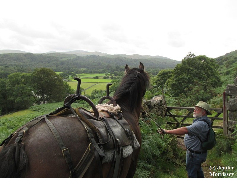
Another type of managed grazing where Fell Ponies are used is sometimes called regenerative grazing, where animal densities, duration, and diversity are chosen so as to benefit the health of the ecosystem both above and below ground. Claire Beaumont at Gowbarrow Hall Farm explains, “The Fell Ponies are a key part of the farm’s ecosystem. We have a huge mixture of native flora, which have all evolved with both cattle and ponies. Many of our species are not palatable to cattle, but the ponies appear to love them, such as thistle, tufted hair grass and rushes. The ponies hold back these species’ dominance, therefore having a positive impact on the farm’s biodiversity.

“From mid Spring to mid Autumn the ponies graze our fell plot, which is a mixture of wet peatland and heather moorland. The heather has benefitted considerably from the area being grazed by the ponies. Their animal impact is making space for new growth, keeping the area diverse. We are also seeing the return of lots of wildlife, including ground nesting birds such as grouse.” (3)

Claire continues, “Unlike conservation grazing which generally requires low numbers of livestock over large areas, we are using a combination of high density grazing with very long recovery periods (up to nine months in some areas) and mixed species grazing with cattle, ponies and pigs. Each of the different species of livestock provide their own benefits, including different grazing properties, different dung types to feed our soil microbes and invertebrates, as well as social benefits.” (4)

Also within the last two years, the movie Life of a Mountain: Helvellyn has brought attention to the use of Fell Ponies for conservation grazing. Libby Robinson of the Fell Pony Heritage Trust appeared in the film and was subsequently interviewed by the Cumberland & Westmorland Herald after the movie’s release. In the newspaper interview, Libby emphasized that Fell Ponies are native grazers that have evolved along with other native breeds of livestock and the wildlife of the area to create the existing habitats and to sustain the biodiversity of the area. She also pointed out that like the other native species of livestock, Fell Ponies “…learn how to graze this way through generations of herd maternal teaching, both intuitive and instinctive.” (5)

Libby continued, “They will eat gorse, rush, thistles and even bracken when it is brown. Also their trampling of bracken in the summertime helps keep the sward open in places so the rare high brown fritillary butterfly can find the dapple shade it enjoys. Sphagnum moss – the foundation plant of the UK peatlands – is helped by grazing Fell Ponies who keep invasive species of plants at bay, like Molinia grass, and maintain micro reservoirs of water through their hoofprints so birds and insects can drink.”

Like all grazing animals, Fell Ponies graze on different plants in different locations at different times of the day and year. Their uniqueness, when combined with other types of grazing animals, can enhance soil health and biodiversity.

Fell Ponies doing beneficial grazing isn’t just something that happens in the UK, though. Eric Wilson shared this story about his Fell Ponies in the state of Oregon: “When I watched the movie Life of a Mountain: Helvellyn, I thought it was interesting that the cattle farmers would purposefully graze Fell Ponies behind their cattle as the Fells would eat the weeds and brush that the cattle left behind. I could relate somewhat. I had a good crop of thistle growing in my pasture last summer. Just as I was starting to go out and remove it, I noticed that my ponies had been chewing on it. So I just let them chew away and all the thistle was gone in a week or two, and I did not have to do a darn thing!” (6)

Fell Ponies, like any grazing animal, have their own patterns of grazing. For instance, they will graze different locations at different times of the day and different times of the year. And they will likewise graze different plants at different times of the day and year. Their digestive systems work differently than other grazing animals, such as cattle and sheep, and likewise their urine and manure have different characteristics, too, so provide different benefits to the soil and plant communities than that of cattle or sheep. As we continue to learn more about regenerative grazing generally, we are also learning more about using Fell Ponies as tools in landscape restoration and health. And we’re finding it’s just one more job that a Fell Pony does well!

  1. Millard, Sue. Hoofprints in Eden. Hayloft Publishing, Kirkby-Stephen, Cumbria, 2005, p. 43.

  2. https://www.cumbriawildlifetrust.org.uk/news/fell-ponies-return-clints-quarry

  3. Fell Pony Heritage Trust Facebook post, 4/14/22

  4. Gowbarrow Hall Farm 7/12/21 newsletter

  5. “Fell Ponies Starring Role in Lake District Film,” Cumberland & Westmorland Herald, 1/9/21

  6. Email from Eric Wilson to author, 5/6/21

Packhorse History in Eskdale and its Surroundings

Esk Dale is truly magnificent, full of contrasts and steeped in history.  It can also boast a unique feature in that, at its head, are the highest mountains in England, the Scafells, and its feet are well and truly in the sea at Ravenglass. – Michael Hartwell in An Illustrated Guide to the Packhorse Bridges of the Lake District (1)

Fell Pony Linnel Doublet looking out over Eskdale from the historic packhorse track between Wasdale and Eskdale over Burnmoor on the author’s 2015 traverse of the track.

The Fell Pony is the native pony of northwest England, including the Lake District.  However, the Fell is often not recognized for its many and diverse roles in the history and landscape of the northern hills.  For instance, in the nomination documents for the Lake District for recognition as a World Heritage Site, the Fell was absent despite its ancestors being the primary mode of transport of goods during the packhorse era and the Fell being a native dweller of the fells like its better-known brethren the Herdwick Sheep.  While packhorse bridges are often recognized as historic and picturesque parts of the region, the many other features that harken back to the packhorse era, including the ponies themselves, are not recognized as such.

From 2016 to 2017, Maggie B. Dickinson wrote a series of thirteen articles for Cumbria magazine about the packhorse history of the area.  Her series built on her many decades of research about packhorse bridges and related features in northern England.  Because of my interest in the working heritage of the Fell Pony, Maggie subsequently gave me permission to build upon her work and document more about how the ancestors of today’s Fell Ponies were used in the commercial and industrial past of the region.  I am grateful to Maggie for sharing her knowledge, her photographs, and her insights with me.

Wordsworth's view of the features of the Lake District as spokes of a wheel radiating from the hub (red dot) at ScaFell.  My progress documenting the packhorse history of the region is hatched in green. 

The poet William Wordsworth, in his Guide Through the District of the Lakes in 1835, encouraged his reader to imagine themselves suspended like a cloud above the Scafells where they would see diverging from their feet numerous valleys “like spokes from the nave of a wheel.” (2) In the illustration at right, the nave or hub of the wheel is shown in red. In hatched green are areas whose packhorse history I have previously explored. For instance, the packhorse history of the spoke that is the Lickle valley is in the southwestern portion of the Lake District (click here if you’d like to read that article). Clockwise from the Lickle is the spoke that is the Duddon valley (click here if you’d like to read that article.) Further north is Burnmoor and its historic route (click here if you’d like to read that article). Counterclockwise from the Lickle is the Furness region which influenced both the Duddon and Lickle valleys (click here if you’d like to read the Furness article). And then further counterclockwise are Morecambe Bay and the sands routes that crossed it (click here if you’d like to read that). Here I will explore the spoke that is the valley of the River Esk, clockwise from the Duddon valley. I will explore Eskdale’s near neighbor, again clockwise, the spoke that is the River Mite, in a future article.

As Hartwell indicates in the opening quote, Eskdale begins under the Scafells and runs to the sea at Ravenglass.  However, some sources say that Eskdale is north of the Esk and Birker & Austhwaite is south of the river.  I will use the more general rather than specific meaning of Eskdale here. 

At one time, Ravenglass was a port town, with a harbor collecting the waters of not only the Esk and the Mite but also the Irt (the next spoke clockwise from the Mite).  Maggie says about Ravenglass’s place in packhorse history, “Ravenglass has enjoyed much activity, especially during the smuggling period.  Apart from the legal import and export of goods, there were hidden dropping off and picking up points used by smugglers in the quietest of places along the coast either side of Ravenglass.  Eventually Whitehaven, a much larger harbour and port to the north, became the main base for shipping and Ravenglass fell into obscurity.”  If you haven’t read Rudyard Kipling’s poem “A Smuggler’s Song,” about pack ponies and illicit cargo, I highly recommend it;  click here to access written, spoken, and sung renditions.

Since the River Esk penetrates deeply into the Lake District, transit through its valley naturally occurred as early as humans were moving about.   Recorded history says that first defense and then trade were the primary reasons for travel through the valley.  Trade began in Neolithic times 4,000 years ago.  Then the Romans built a road through Eskdale for defense purposes in the first century AD and constructed forts at either end of the valley to oversee and protect their interests.  It is likely that they used pack ponies to access areas away from their roads.  Supporting this assertion, Sue Millard notes in her book A Century of Fells that pack saddles were found during excavation of Vindolanda, a Roman Fort east of Carlisle along Hadrian’s Wall. (3)

Subsequently, during the monastic period (roughly 1000 to 1500AD), Furness Abbey had interests in Eskdale and Miterdale and used packhorses to move goods.  And then in the post-monastic period, packhorse trains followed numerous tracks through the valley taking goods for export to the ports at Ravenglass and Whitehaven and bringing imports, legal and otherwise, on the return journey. 

Anyone interested in the history of Eskdale is indebted to Miss Mary C. Fair, an amateur historian and archaeologist who lived in the valley from 1875 to 1955. Miss Fair published numerous papers about Eskdale in the Transactions of the Cumberland and Westmorland Antiquarian and Archaeology Society (referred to here as Transactions). More recently, the Eskdale & District Local History Society completed a four-year project revisiting Miss Fair’s work, publishing Walking In The Footsteps of Mary Fair (Footsteps) in 2008. I am grateful to Jamie Quartermaine of Oxford Archaeology North for sharing a copy of Footsteps with me.

While Mary Fair’s work was principally about the Roman period and thereafter in Eskdale, she also made notes about the Neolithic period (4,500-2,350 BCE).  I was fascinated by a description of the Neolithic period in Footsteps.  Specifically, I was intrigued that “Craftsmen were fashioning the volcanic tuffs found on the high central and western fells into stone axe heads, at the time a valuable and tradable commodity.  Axes from this area have been found in large quantities in Ireland and as far afield as the northern coast of France, which suggests that the centre of the Lake District was, in a manner of speaking, a silicon valley of its day.” (4)  This telling indicates that international trade from Eskdale was actively underway up to 2,300 years BCE, which left me wondering if pack ponies were in use earlier than the Roman period.  On Dartmoor, ponies were domesticated around 1500 BCE, with horses domesticated about 500 years earlier.  (5)  Perhaps in time we’ll know more about how long ago ponies were domesticated in northwest England and if they may have helped with trade during the late Neolithic period.

copyright Jenifer Morrissey 2022

This map locates features in Eskdale and nearby areas in the Lake District of Cumbria with connections to packhorse transport, including mines, Woods, peat, mills, and more. (c) Jenifer Morrissey, 2022

The map here shows the valleys of the River Esk and River Mite, with the valleys approximated in pale yellow.  There is a low pass between the two valleys at Eskdale Green, roughly in the center of the map.  The Duddon Valley, our previous topic, sits off to the lower right of this map.  In addition to my gratitude for Maggie B. Dickinson’s assistance, I am grateful to Fell Pony trekker Vyv Wood-Gee for her interest in packhorse-related features and her sharing of photographs that you will see below.

The map indicates the rough locations of features that are related to the historic use of packhorses in Eskdale and its environs.  While ‘packhorses’ is the usual term, history says they were ponies by stature since they were usually less than 14hh; a stout but shorter equine made it easier to lift the loads onto the pack saddles.  While some of the packhorses in use during the peak of the packhorse era were imported - jaggers from Germany for instance - some were also likely locally reared and therefore ancestral to today’s Fell Ponies, the breed that calls the region home today.

Purple elements on the map indicate Roman features, including the road from upper right to lower left.  Black lines are modern roads.  Green lines indicate historic packhorse tracks that may today be footpaths or bridleways.  Often modern roads follow the same routes as historic tracks because those routes were found over time to be the most efficient way to get from point A to point B.  A narrow-gauge railway ascends the Mite valley from Ravenglass to the pass over to Eskdale and terminates at Dalegarth near Boot.  Its track is shown by a double hatched black line.  Another full-scale railway hugs the coastline.  Maggie says, “This is the Cumbrian Coast Line which runs from Carlisle and down through Workington, Whitehaven, and to the southern end of the Furness Peninsula to Barrow and then up through Ulverston, Grange-over-Sands to Carnforth near Lancaster where it connects with the West Coast Main Line” 

courtesy Vyv Wood-Gee

Fell Pony Wellbrow Drifter ambles down the old Roman road under Muncaster Fell in Eskdale in September 2021.  Copyright and Courtesy Vyv Wood-Gee

On the map, ‘Grounds’ are shown as green circles. These are current or former farms with historic associations with Furness Abbey during the monastic period. The Lake District National Park World Heritage Site documentation says about ‘Grounds:’ “Following a formal agreement between the Abbot of Furness and squatters in 1509, a series of permanent steadings was established by carving out small, irregular fields from the monastic commons, and building a basic, humble farmstead or ‘Ground’. Each ground is named after the original family….” (6) Maggie considers the monastic era to be the beginning of significant use of packhorses for moving goods, though there is evidence that the Romans used packhorses in rougher remote areas in their era. Places like Grounds, as part of the Abbey’s network, would have been serviced by packhorses.

‘Bridges’ are either known to have packhorse associations or are worthy of further investigation for packhorse associations.  Bridges have the most obvious connections to packhorses and they have been the most researched and identified.  However, some bridges have yet to be given the credit that they deserve and others are on historic packhorse routes and have been rebuilt since the packhorse era.  Maggie and others have found many bridges that are not yet on the most common lists of these important features.  Bridges are considered to be genuine packhorse bridges when they are on a known packhorse route, have low (or even no) parapets to allow panniers to pass over them, are narrow and were built during the packhorse era.  The packhorse era is generally considered to have been prior to about 1750 when the turnpike roads began to be constructed in earnest.  However, in places, road improvements didn’t come until much later, so packhorses continued in use.

‘Woods’ were forests managed historically for making charcoal and other woodland products.  As Maggie points out, some forests were coppiced:  “managed by pruning so that new growth sprouted back quickly from the roots or stumps, thereby creating wood suitable for charcoal and other purposes.”  Charcoal was the fuel source for iron smelting, an early and prominent industrial activity of Eskdale and Miterdale.  Bobbins, an example of other woodland products, were needed by the Lancashire cotton mills and were a common product of the woodlands of the region. Maggie says, “These bobbins were sent to the Lancashire Cotton Mills in the mid-1800s, and at this time the packhorses were still in full swing in such remote areas.”

Mines, quarries, and drifts are shown, though we do not have clear information about the dates of their workings.  Hence we don’t specifically know which ones would have been serviced by packhorses.  An article on the mines of Eskdale by the Cumbria Industrial History Society says, “The iron ore deposits, reddish in colour, outcrop on the surface and must have been used for ‘ruddle’ or pigments since early times. Iron has been smelted in the valley since at least Roman times, as the many small banks of slag testify. Presumably local ore was used.” (7) During their era, packhorses would have been used to move ore from mines to smelting sites.

Pitsteads are remnants of charcoal making platforms in the Woods.  Their locations are from Mary Fair’s publications in Transactions.  Pack ponies were used to transport charcoal from the Woods to the iron smelting sites called bloomeries during their era.

copyright Maggie B Dickinson

The Woolpack Inn in Eskdale has packhorse era connections. Copyright and courtesy Maggie B. Dickinson

On the map, ‘Inns, halls, castles’ are places of manorial activity, lodging and/or eating/drinking with known or probable packhorse associations. These places were near a known packhorse route. Additionally, they would have had a place for the packmen to sleep, had enclosed grass paddocks for the ponies to graze in overnight, and had space under lock and key for the packs to be stored.

Maggie adds, “In addition to the monastic system, there were other factors we inherited from the French after the Norman Conquest, like the feudal system which brought castles into being, so that with monasteries, priories, abbeys, castles, manor houses and the like, the population grew around these locations, and the need to trade became vital, so that market charters (many of which still exist) were given to towns and villages for the ease of trade, hence the need for pack ponies on routes where wheels could never go.”

‘Mills’ were water-powered so are along water courses and were used for corn as well as for processing wool and cloth (woolen, linen or hemp).  Other mills made wood products.  Prior to good road access, packhorses would have brought raw materials to the mills and taken finished products away to market. 

Bloomeries are shown on the map.  Iron ore was smelted at them, using charcoal for fuel.   Iron ore during the medieval period would have been brought to the bloomeries by packhorses or cart and horse, and charcoal would have made the short trip from the Woods to the bloomeries similarly.

‘P’ marks the locations where peat was cut and stored to be used as fuel or where evidence of its transport has been found.  In a 1984 Transactions paper by Angus Winchester, the author suggests that in Eskdale, peat was often sledged - a horse or pony put to an implement drug on the ground on which the peat was stacked.  However, he also notes use of pack ponies from some peat storage huts where sledge tracks were not found.  “The position of some of these huts near steep slopes with no evidence of well-built tracks perhaps suggests that peat was transported from them without vehicular aid, either in panniers on pack horses, or on human backs.” (8)

Finally, on the map, a church with a packhorse association is indicated, as is Hollins Farm, an overnight stop by drovers and probably packmen.

Courtesy Rob Farrow via geograph.co.uk, Creative Commons license 2.0

The descent into Eskdale from Hardknott Pass.  Bob Orrell and his Fell Ponies used this road on their Saddle Tramp in the Lake District.  Courtesy Rob Farrow via geograph.co.uk, Creative Commons license 2.0

At the far right of the map, Hardknott Pass is indicated. This is the first of several important passes into Eskdale from other parts of the Lake District. The Roman Road comes over Hardknott Pass, as shown by the purple line, connecting two of the approximately 25 Roman forts that were built in Cumbria from AD71 to AD383. The Roman roads in Cumbria were remarkably straight in most places. These are in contrast with the later packhorse tracks which tended to follow grades to make it easier on the loaded animals. And while the Roman roads connected the Roman forts, the packhorse tracks tended to connect market towns, quarries, and farms. According to the Roman Roads Research Association, “From the top of the pass the modern and Roman lines coincide but at the end of the hairpin bend that swings to right…, the Roman road diverges and takes a higher line to the fort.” (9)

In 1982, Bob Orrell published his book Saddle Tramp in the Lake District about his travels around the region with two Fell Ponies.  Bob, Thor, and Jewel traversed Hardknott Pass, with Bob expressing his appreciation for the packhorse history, and harrowing present, of the route:

…we plodded up the tortuous pass, overtaken at frequent intervals by startled motorists, surprised to find two pack-pones where they rightly belonged.  If the occupants of those brightly painted metal monsters did but know it, the horse had carried goods and people over Hardknott Pass for hundreds of years and it was the last route to be regularly used by the pack-horse gangs, before wheeled transport finally ousted them from the Lake District forever…. Descending into Eskdale we had to take great care on the smooth tarmac.  The spinning tyres of countless cars had left a coating of rubber on each bend and I had one heart-stopping moment when both ponies skied down a particularly greasy section and slid to a halt on the brink of a long drop into the valley. (10)

In Saddle Tramp, Bob also related an often-told tale about how a packhorseman was assisted by a black stallion on their travels from Kendal over Hardknott Pass on their way to Whitehaven:

The locals tell a grand story about a character who used to travel over Hardknott Pass with a gang of pack-horses, plying between Kendal and Whitehaven.  He rode a pony and, being rather fond of his ale, had a habit of dashing ahead of his pack-horse [gang] to an inn, where he would sit drinking until they had passed, led by an old black stallion who probably knew the way better than anybody.  A few more drinks and he would overtake them again and wait at the next inn.  Apparently he did this all the way to Whitehaven, but whether he managed to ride back to Kendal, or was carried, history does not record. (11)

courtesy Mountain Coward

From above Hardnott Roman Fort looking toward Eskdale. The Fort is midground center-left, and Ravenglass and the Irish Sea are at the distant upper right.  Copyright and courtesy Mountain Coward

  Hardknott Fort is one of the most impressive sites of the Roman Occupation to be found in the whole of Britain.  – Robert Gambles in The Story of the Lakeland Dales (12)

Hardknott Fort is shown as a purple diamond on the map.  While the Fort did not have known packhorse associations, it is nonetheless an important landmark in Eskdale and is accessed by the Roman Road that was later used by many packhorse gangs. 

Footsteps paints a dramatic picture of the setting of Hardknott Fort. “At the head of the valley, perched on the edge of a rim of crags, is Hardknott Fort with its impressive backdrop of England’s highest mountains. One of the best descriptions of the fort was made by Chancellor Ferguson during the first excavation in 1892. He likened it to ‘an enchanted fortress in the air; the work of superhuman powers to the native Britons.’” (13)

Robert Gambles in his book The Story of the Lakeland Dales, expands on his quote above by explaining that the impressive Hardknott Fort was actually not long-lived.  “Hardknott had a fairly short life as an active military station.  It was probably built towards the end of the first century AD and appears to have been destroyed and abandoned towards the end of the second.” (14)

According to Maggie’s research, the Roman route over Wrynose and Hardknott passes was known as Smuggler’s Road and is believed to have been the last of Cumbria’s packhorse roads.  In an article for Cumbria magazine, she told the story of moonshiner Lanty Slee.  “Not content with local trade he would use the cover of darkness to trek over Wrynose and Hardknott passes – two of the hairiest roads in the country – either leading a single packhorse with bulging panniers or among a group of smugglers, [heading] for the old Roman port of Ravenglass.  There he exchanged whisky for foreign goodies such as rum, brandy, tobacco and sugar….  On risky journeys Lanty’s whisky was frequently carried in pigs’ bladders, rather than bottles….  When his dogs gave [an alarm] signal he could split the skin and rid himself of the evidence.  The round trip from Langdale to Ravenglass on foot, of almost thirty miles, was arduous and life-threatening in inclement weather, and poses the question of when Lanty found time to sleep.”  (15)

copyright and courtesy Maggie B. Dickinson

Brotherilkeld, an historic farm with connections during the monastic era to Furness Abbey and also having more recent Fell Pony associations.  Photo copyright and courtesy Maggie B. Dickinson.

At the base of the pass, we find on the map three features: a Ground, a bloomery and a pitstead.  The Ground is referred to as Brotherilkeld (or similar spellings) and was connected to Furness Abbey during the monastic era.  Brotherilkeld has been owned by the National Trust since 1961.  According to the National Trust website, “Like many other places in the Lake District, Norse settlers and farmers left their mark through numerous place names, including Brotherilkeld meaning ‘the booth of Ulfkell’.” (16) Booth is an old English word for a livestock shelter according to Merriam-Webster.

Gambles explains in The Story of the Lakeland Dales: “In 1242 the Abbot negotiated a remarkable transaction whereby in exchange for a coastal property at Monkfoss, near Black Combe, the Abbey acquired 14,000 acres of Upper Eskdale including the already long-established sheep farm or ‘herdwick’ of Brotherilket.  They thus obtained not only a valuable economic asset but also control of the communications routes, via Hardknott, to their other possessions in High Furness and, via Esk Hause, to their farms and granges in Borrowdale.  They also secured access, via Lingcove (where their bridge still stands) and Ore Gap, to the iron furnaces in Langstrath for the smelting of the ore they mined in Eskdale.”  (17)  The bridge that Gambles mentions here is shown at the extreme upper right corner of the map. 

Brotherilkeld has connections to Fell Ponies, not only because Bob Orrell and his ponies Thor and Lucy camped there for two nights on their Saddle Tramp.   In a 2012 article in The Guardian, Tony Greenbank told a story about the Harrison family that currently stewards Brotherilkeld.  “[Eric Harrison’s] family has shepherded Brotherilkeld farm at the head of Eskdale for more than 100 years and he has farmed here for 40 years plus with his brother Geoff….  When he was eight, Eric accompanied farmer Tom Crozier and a horse called Zebe that worked on the farm to Harter's summit [Harter Fell is the tallest peak to the south of Brotherilkeld, between there and the Duddon Valley].  Eric had hoped – as boys will – to hitch a ride on the sturdy fell pony, but Zebe (which always wore a chain so it could be readily caught when it trod on the links) was carrying a bag of cement needed to make a platform for the Ordnance Survey trig point on top. Eric was forlorn to find that neither could he ride down. The steep angle tipped him headlong over the horse's head, down towards the leafy belt of trees by the river Esk.…”  (18)

copyright and courtesy Maureen Fleming

Lingcove Bridge over a headwaters tributary of the River Esk.  Photo courtesy and copyright Maureen Fleming

Not far from Brotherilkeld on the map is a marker for a bloomery and pitstead. These features are mentioned in Mary Fair’s 1921 Transactions paper called ‘Bloomery Sites in Eskdale and Wasdale (Part 1)’: “To the right of the road ascending [Hardknott] pass about 50 yards over the bridge are remains of a hearth or kiln, the bottom of which is covered with burnt matter…I have not been able to find a slag-heap, but through the gate above, at the right beside the ancient track leading from a ford, is a heap of iron ore. There are charcoal pitsteads in the wood at the opposite side of the road from the hearth.” (19) During their era, pack ponies would have moved charcoal from the pitstead to the bloomery and ore from mines to the bloomery.

Above Brotherilkeld over a tributary of the River Esk sits Lingcove Bridge, also called Throstlegarth or Roman Bridge.  It physically has the characteristics of a packhorse bridge in terms of width and low or no parapets.  However there is disagreement about it being on a known packhorse route.  Hinchliffe, widely considered one of the best authorities on packhorse bridges, wrote in his book A Guide to the Packhorse Bridges of England, “It is said to be on a route leading from Brotherilkeld via Ore Gap into the Langstrath valley where there was a smelting furnace or bloomery; a route used by iron miners.  This is difficult to confirm from present evidence because the path between Brotherilkeld and Ore Gap is on the same side (east) of Lingcove Beck throughout.” (20).  Gambles says in the quote above that the bridge has monastic connections, which would confirm its connection to packhorses since Furness Abbey made significant use of pack ponies.  Hartwell in his book on packhorse bridges also indicates monastic connections, “There has probably been a crossing at Throstle Garth for hundreds of years….  The monks from Furness Abbey had a monastic sheep pasture around Throstle Garth Bridge where the remains of the sheep folds are still in evidence.” (21) 

Also above Brotherilkeld are locations of peat moss.  In Winchester’s 1984 Transactions paper called ‘Peat Storage Huts in Eskdale,’ he wrote, “A survey of these peat storage huts in Eskdale was undertaken in August 1982, with the help of a small group of American volunteers, recruited by the Earthwatch organization of Belmont, Massachusetts, as part of a project organized by the Brathay Centre for Exploration and Field Studies…. What is unusual about the Eskdale huts is their location out on the fellside: most other Lakeland ‘peat houses’ were situated among the other buildings of the farmstead….  All that can be said with certainty about the origins of the peat scales is that some, at least, were in existence by the late 16th century.”  (22)  Pack ponies would have been one form of transport available at the origins of these peat scales.

During the survey of Eskdale peat scales, thirty-five huts were located, and two types were identified.  Type A huts were more primitive and likely went out of use in the mid-1800s.  Type B huts had slate roofs on their stone walls, as compared to bracken on the Type As, and the Type Bs “were nearly all associated with well-made sledge tracks and several had stone-built ramps leading to their upper doorways and levelled areas in front of their lower entrances….  The absence of the [Type B] storage hut from the upper reaches of the valley may indicate that the smaller deposits of peat in that area had ceased to be worked (or had been worked out) by the date of the change of building style.” (23)  On the map, the three indicators marking Peat are from this survey, with two of the three being Type A huts and the third, the farthest north, being a hut of unclassified type.  Pack ponies were known to carry bracken, so it’s possible that the construction of the Type A huts may have involved them.

by Mick Knapton and used via Creative Commons License 3.0

Wha House Bridge over the River Esk.  While not considered a packhorse bridge, its location suggests that a bridge likely existed in this location during the packhorse era.  Photo by Mick Knapton and used via Creative Commons License 3.0

Traveling down the river and the Roman Road we come to a bridge over the River Esk. Wha House Bridge is not considered a packhorse bridge. However, its location both topographically and on the Roman Road suggest a bridge in this location likely existed during the packhorse era and would have been used by packhorses. With a known packhorse route on the south side of the river and the Roman Road providing good transit on the north side of the river, and with packhorse-related features on both sides of the river, it seems likely that a bridge at the Wha House location would have been an important feature, just as it is now for modern vehicular traffic.

There are three mines, quarries or drifts shown north and south of Wha House Bridge.  These features were located via a map called ‘Detailed Old Victorian Ordnance Survey Map 1888-1913.’  This map, which I will refer to as Detailed Old Map, has been a valuable resource for investigating routes, tracks, and bridges as well as the location of peat moss, quarries, mines and drifts.  (24)

copyright and courtesy Maggie B Dickinson

Doctor Bridge across the River Esk is an important link between numerous historic packhorse routes.  Copyright and courtesy Maggie B. Dickinson

A green line on the south side of the river heading west from Wha House Bridge is an historic packhorse track according to Bob Orrell in Saddle Tramp: “…having spent much of the morning talking to the Harrisons [at Brotherilkeld], the day was well advanced when I rode Thor down to Wha House bridge and a gate leading into a tree-lined meadow. The old pack-horse track crossed the meadow to a wood and on through bracken, so tall at times the ponies were out of sight under it. Crossing the boulder-strewn beck, the track improved, following a well-worn route through pasture land and numerous gates, to Penny Hill Farm. In the days when packhorses and droves of cattle passed by from Ravenglass, the farm was an inn called Pyet’s Nest.”(25) On the map, Pyet’s Nest is indicated. Maggie suspects Pyet is a surname.

Continuing on from Penny Hill Farm, still on the south side of the river, we come to a bridge across the Esk.  Today the bridge is called Doctor Bridge, and there is a popular tale from 1734 about a local surgeon living at Penny Hill.  It is said he wanted the original packhorse bridge at this location widened to accommodate his pony and trap.  However, Gambles and colleagues published an article in the Friends of the Lake District’s newsletter Conserving Lakeland that tells an alternate interpretation of the bridge’s widening. 

According to the article, documents uncovered at Penny Hill Farm say the bridge was widened circa 1817.  In addition, the bridge wasn’t called Doctor Bridge until 1860 or so on an Ordnance Survey map.  “So the link between the ‘doctor’ and the ‘bridge’ is by no means proven,” say the article’s authors.  Nonetheless it is clear from its location that it was an important feature during the packhorse era.  Hartwell says in his book on packhorse bridges, “…although today it provides access to only two or three farms, it was (in the 1700s) on an extremely busy route.  In fact, it was on the main thoroughfare between Esk Dale and the Duddon Valley.” (26)  There is a picture of this ‘main thoroughfare’ below.

The indications of peat on the map south of Doctor Bridge and Penny Hill were identified by Winchester in his 1984 Transactions paper.  Three in the more eastern location were Type A, or older, and the more westerly one was a Type B or newer and more elaborate.  Winchester asks an interesting question in his paper after reviewing a relevant lawsuit: “an attempt must be made to consider why the inhabitants of Eskdale went to the expense of building such structures, while many other Lake District communities seem to have succeeded in obtaining their peat without storage huts on the commons.  The reason given in the 1795 lawsuit papers… was that ‘it is often difficult to win their peats in summer’. Presumably, the phrase ‘to win’ is used here to cover the whole process of obtaining peats, from cutting them to bringing them to the farmstead. Inability to complete the process in the summer could arise from two factors: either the climate on the exposed, high level peat mosses might have been too wet to allow the peats to dry sufficiently, or perhaps, aggravated by the slowness of drying, the farming calendar of the summer months (hay-making, sheep clipping, harvest) might not have allowed sufficient time to carry the peats down….  It may be argued that precipitation in Eskdale is not appreciably higher than elsewhere in the Lake District and that climate alone cannot explain the need for peat scales in the valley. The relatively high altitude of the peat deposits would account for some difference in climate between the Eskdale peat mosses and those of some other valleys, but the decisive factor may perhaps have been the extremely steep fellsides of Eskdale which separated the farmsteads from their peat supplies. It might well have been considered preferable to carry completely dry peat down these at intervals during the winter than to carry the extra weight of water in crumbling, semi-dried peats in the summer.” (27)  Certainly if pack ponies were used to carry the peat, having the peats be drier and lighter would allow a larger load to be more safely carried down the steep tracks.

On the map, the mine noted south of Penny Hill is an old copper mine.  Its location is documented in the 1923 list of Ancient Monuments in Birker and Austhwaite.  (28)  No indication of the dates of its working were given, so it’s unknown whether it would have been serviced by pack ponies.

Woods are indicated on the map along the river downstream from Doctor Bridge.  The Detailed Old Map names the first pair Oak How and Crag Coppice and the downstream pair Ash How and Great Coppice.  Mary Fair refers to them as Birker Wood, and she found numerous pitsteads there.  According to Maggie, ‘how’ is Norse for hillock. 

A bloomery is indicated on the map between the two pairs of Woods.  Mary Fair calls the bloomery Low Birker and she also locates pitsteads in a Wood nearby.  “[The bloomery] is situated on the ancient road on the south side of the Esk….   In the field at the other side of the wall there are heaps of oxide mixed with metallic ore on the banks of the stream, and red oxide and slag are scattered here and there in the earth of the field lately turned up by the plough….  There are numerous charcoal pitsteads in Birker Wood.” (29)  Charcoal would have been moved from the pitsteads to the bloomery by packhorse during their era.  Ore may also have been moved to the bloomery the same way in that era.

copyright and courtesy Maggie B Dickinson

Sign marking the site of the historic Woolpack Inn.  Copyright and courtesy Maggie B. Dickinson

Across the river from Doctor Bridge and Penny Hill Farm, two features lie on the Roman (and modern) road. The first is a bridge across a tributary of the Esk, and the second is an inn. The bridge crosses Blea Beck and is called, suitably, Blea Beck Bridge on the Detailed Old Map. Like Wha House Bridge, it is not considered a packhorse bridge but a bridge at this site likely existed during the packhorse era when a route likely followed the Roman Road.

copyright and courtesy Eddie McDonough

Herdwick sheep and spectators at Eskdale Show in 2015 with the dramatic fell backdrop.  Courtesy Eddie McDonough

The inn, on the other hand, has known packhorse associations and is pictured above. The Wool Pack Inn, according to Mary Fair, was originally called the Dawson Place. (30) And the Old Cumbria Gazetteer website calls the location Dawson Ground, hinting at a possible historic connection to Furness Abbey. (31)

A visitors’ guide website says, “The isolated Woolpack Inn and the nearby Youth Hostel are well frequented by hill-lovers for most of the year, but on the last Saturday in September the narrow road is thronged for the Eskdale Show.” (32) 

The Eskdale Show history page once included this tidbit about the Woolpack and the iconic Lake District sheep breed the Herdwick: “In some of the early years, over 500 [Herdwick] tups came to Eskdale Show, the majority of which would be walked there, taking several days to reach the Woolpack. For example, Keswick sheep would be walked up Borrowdale then over Styhead Pass into Wasdale, then over Burnmoor Tarn track into Boot and on to the Woolpack. In 1867 there were entries from as far away as Threlkeld, Buttermere, Windermere, Coniston and Cockermouth. It would have been a tremendous sight seeing all the Herdwicks converging into the Show field.” (33)

copyright and courtesy Maggie B Dickinson

Hollins Farm in the 1970s.  The name 'hollins' indicates it was used by drovers when moving cattle and may have been used by packmen in their era.  Copyright and courtesy Maggie B. Dickinson

Down the Roman Road from the Woolpack Inn and slightly north is Hollins Farm. The name ‘Hollins’ indicates the farm was once used by drovers for overnight stops. Maggie says it was possibly also used by packmen. On the Detailed Old Map, numerous tracks are shown to the farm, including coming down Whillan Beck connecting to the historic track from Burnmoor.

Along that track, a mill is shown called Gill Bank.  On the Detailed Old Map, it is labeled a sawmill.  The Cumbria Industrial History Society says it was a carding mill in 1810. (34)  Carding mills prepared wool for spinning by brushing the fibers to evenly align them.  The PastPresented website includes a collection of deeds for Gill Bank Farm beginning in 1696, with a miller in residence as early as 1754, as well as a weaver.  Starting in 1813, the noted poet William Wordsworth owned Gill Bank Cottage for a time.  ‘Peathouses’ are also mentioned in 1813. (35)   On the Old Detailed Map, a bridge is shown crossing Whelan Beck between the farm and the mill.  It is possible that pack ponies would have serviced this mill and the peat houses prior to improved access.

Continuing down the Roman Road from Hollins Farm is the village of Boot.  According to Hartwell in his book on packhorse bridges, “The name ‘Boot’ is derived from the Viking for ‘dwelling place.’” (36) 

courtesy Maggie B Dickinson

Postcard of Gill Bank(s) Mill, north of Boot, circa 1920. Courtesy Maggie B Dickinson

The History page of the Eskdale website elaborates on the Viking/Norse period of the region’s past. “The most influential settlers, though, were the Norsemen in the 9th and 10th centuries. These were not the loot-and-pillage Vikings who swept the east coast but farmers who recognised the landscape from their homeland….Many of the thick walls at Boot and Brotherilkeld are a result of their [Viking] land clearance. Their language is also still very much alive in many of Eskdale's names, like Blea Tarn, Scafell, Birkerthwaite, Scale Gill and Dalegarth.” (37) Thwaite, for instance, means clearing in the forest.

Boot Bridge in 2015 with two Fell pack ponies and the author, right, and Christine Robinson, left.

Between the Woolpack Inn and the village of Boot, there are numerous quarries, mines, or drifts indicated on the fellside north of the river.Gambles, in The Story of the Lakeland Dales, says, “Eskdale’s iron ore was mined for close on 2,000 years from Roman times until the last venture ended in 1913. The haematite outcrops may best be seen on the fellsides near Boot.” (38) Those more recent mineral mining ventures as well as an interest in the local granite inspired the building of the narrow-gauge railway that dominates the experience of many Eskdale visitors today and which also of course put natural horsepower out of business.

My introduction to Boot was quite different from that of most modern visitors.  It was via, not surprisingly, a packhorse bridge.  Boot Bridge (also called Mill, Eskdale or confusingly Bleabeck) crosses Whillan Beck, a tributary of the Esk.  The bridge gives access from Boot to an historic corn mill.  It is also on an important packhorse route to Burnmoor and thence Wasdale.  The route over Burnmoor to Wasdale was also a corpse road; click here to read more.

copyright and courtesy Maggie B Dickinson

Eskdale Mill in Boot on the left with Boot village ahead over the packhorse bridge and used millstone in right foreground.  Copyright and courtesy Maggie B. Dickinson

Bob Orrell points out in his book Cumberland’s Rum Butter Coast that, “Eskdale is one of the few valleys in Cumberland that does not have a lake you can sit by, but in the hamlet of Boot close by the station, there is Eskdale Mill, that has a recorded history going back to 1294 and is claimed to be one of the oldest water-powered corn mills in England.”(39)

The mill’s website is very informative.  For instance, it says that “The earliest millstones would have been made from English millstone grit brought here from the Pennines.  Cologne stones from the Rhineland were probably installed during the middle of the 1700s to grind imported wheat.” (40)  The Pennines lie to the east of the Lake District.  Since those earliest millstones were installed prior to the mid-1700s, it begs the question of if and how natural horsepower would have been used to move them from the Pennines to Boot.  Perhaps over Hardknott Pass?  Or by boat to Ravenglass and then up the Roman Road somehow?  So far, Maggie has been unable to discover how the millstones were transported.

The mill website then goes on to say, “People began to combine water-powered corn mills with corn-drying kilns during the 18th and 19th centuries. These kilns were needed to dry out the damp grains, particularly oats, in the colder and wetter areas of Britain, including the Lake District. They could then be ground effectively by the millstones. At Eskdale Mill a permanent, purpose-built kiln was added between 1795 and 1819, using locally-cut peat for fuel. Since at least the 1500s Eskdale people had enjoyed the right to cut turves of peat from the common land. Peat was cut from the moorland above the mill.”  (41)

The mill website also says, “Farmers usually delivered their grain to the mill themselves, but the miller would return the ground flour using his own horse and cart.”  (42)  Maggie points out in her Cumbria article about mills that this mill is a ‘bank’ mill, taking advantage of the sloped terrain.  “The pack teams climbed to the higher ground at the rear of the split-level structure to access the drying kiln, where their panniers could be directly unloaded to avoid hoisting.  Oatmeal and barley were the most popular local grains for milling because wheat was a luxury and tended to be grown on the coastal plain.” (43)  The transport of peat to the kiln of course might also have been accomplished by pack pony.

Courtesy Kate Hughes, Eskdale Mill manager

Historic pack saddle at Eskdale Mill in Boot. Courtesy Kate Hughes, Eskdale Mill manager

Of particular interest to us at the mill today is an historic packhorse saddle.  Hinchliffe says in his 1994 book about packhorse bridges regarding the pack saddle display at that time: “The small exhibition inside the mill displays a padded wooden packsaddle on which were loaded two sacks of corn.  The display also notes that there was once a regular weekly gang of 20 packhorses en-route through Boot from the west to cross Hard Knott and Wrynose on the way to Ambleside.  From Boot they would probably cross the other Eskdale packhorse bridge - Doctor’s Bridge.” (44)

Fell Pony Hynholme Amber looks toward a peat storage hut along the track from Boot to Burnmoor in 2015.  From this perspective it appears to be a Type B or more modern peat scale.

On the map, along the historic track from Boot north to Burnmoor and Wasdale, peat activity is indicated, as suggested by the mill website. In Winchester’s 1984 paper on peat storage huts in Eskdale, he wrote, “The largest concentration [of peat scales] is the cluster of nine huts on Boot Bank at the head of the track from Boot to the peat mosses on Longrigg.”(45) The photo here shows a hut near Longrigg. I didn’t know at the time that I took the photo that the structure had packhorse associations, or I would have gone to investigate! From this photo it appears that this is what Winchester in his Transactions paper describes as a Type B or more modern peat scale, built to take advantage of the slope so that horse or pony drawn sledges could be pulled to the top to unload fresh peat and to the bottom to load dried peat for transport to Boot village below.

The historic packhorse track from Wasdale and Burnmoor continues through Boot to the south.  First the track passes a Wood, called Hows Wood on the Detailed Old Map.  The track then stops at the only church shown on the map.  The reason St. Catherine’s Church is shown on the map is that the historic route from Wasdale was not only used for movement of goods and livestock but also as a corpse road.  Bob Orrell in Saddle Tramp explains, “In the days before Wasdale Head had its own consecrated ground, those unfortunate enough to expire in this remote corner of Cumberland were denied their final rest until the mortal remains had been carried, on horseback [over Burnmoor], for burial to St. Catherine’s in Eskdale.” (46)  To read more about this corpse road including the numerous ghost stories associated with it, click here.

Across the river from St. Catherine’s, numerous features are shown on the map.  The mines that are indicated are from the Detailed Old Map which shows numerous old drifts.  Mary Fair confirms these features.  The Detailed Old Map also shows Force Wood along the tributary of the Esk that is called Birker or Stanleygill Beck. 

The location of the bloomery is from Mary Fair’s work.  She called it Underbank Wood, indicating another Wood was in the area.  “This is across the river from the old church, a little to the east…  During the time in the 19th century when iron ore was mined at Boot, operations were also carried on here. A bridge was built across the Esk carrying a waggon-way to an adit in the fell side, now fallen in. There are other numerous shafts sunk in the fell side. The waggon-way joined the railway (crossing the high road and the Whellan Beck), between Boot and Beckfoot.” (47)  If operations were carried on here before the 19th century, then this bloomery may have been serviced by packhorses for ore and for charcoal.  And of course it’s possible that the wagons were sometimes pulled by ancestors of today’s Fell Ponies, if not by horses.

courtesy Mountain Coward

Ellerbeck Bridge. Courtesy Mountain Coward

Going up Birker Beck past Force Wood, there are two Grounds and two bridges. The Grounds are called Low and High. Being Grounds, they have an historic connection to Furness Abbey which was a major user of packhorses and builder of packhorse bridges. The two bridges in the area are called Whincop and Ellerbeck, and for numerous reasons they are worthy of further investigation as packhorse bridges. Their proximity to the Grounds, their proximity to a major route to the Duddon Valley, and because of their appearance all suggest that they could be genuine packhorse bridges.

Whincop Bridge. Courtesy Mountain Coward

Downstream on the south side of the Esk from Birker Beck we see a cluster of features: an Inn, a bloomery, a pitstead, a bridge, and a Wood. The Detailed Old Map locates Newhall Coppice and Low Wood here. The ‘Inn, Hall, or castle’ is Dalegarth Hall, the subject of a 1928 Transactions paper by Mary Fair. The paper’s introduction explains how far back the place has been inhabited.“ The ancient habitation on the south bank of the Esk known today as Dalegarth Hall is of interest on account of its long association with a branch of the distinguished family of Stanley [who farmed in the valley for over 500 years…].It is a matter of general knowledge that the original name of the estate was Austhwaite, the occupants taking their name from it, the manor being granted by one of the Boyvilles in 1102 to the family styling itself de Austhwaite who remained in possession till about 1345 when the line became extinct in male succession, the heiress, Constance daughter of Thomas, the last de Austhwaite, marrying Nicholas Stanley of Greysouthen. We first hear of Dalegarth in 1437, when Thomas Stanley, great-grandson of the above Nicholas, is recorded as being of Dalegarth when he married Anne Hudleston.” (48) It is clear from this long history that packhorses would have serviced Dalegarth Hall for some time.

In her 1921 Transactions article on bloomery sites in Eskdale, Mary Fair describes the nearby bloomeries and pitstead.  “There are two (if not more) bloomery sites here….  [No. 1] is situated about 100 yards through the wood east of the gate by Turn Dub. There is a small heap of slag on the old road, another to the right in the wood, and over a wall to the left, more heaps of heavy slag on the bank of a small runner. No trace of hearth. There are heaps of charcoal in the vicinity, and pitsteads in the wood….  No. 2 is in the wood beside the road immediately behind Dalegarth Hall. This appears to have been a more extensive working than the other, judging from the slag-heaps. There are also the remains of a hearth which is about 20 feet in external diameter at the top. There is a well-defined channel or conduit leading from the bottom to a trough made of rough masonry. Adjoining are small heaps of charcoal and patches of oxide puddle.”  (49)

She continues, “I have been told by a dalesman that his grandfather could remember the smelting of iron in the woods in the old rude way, so that many of these small sites may be comparatively modern. Iron ore abounds in the fells all round Eskdale, and no doubt has been worked from early times. Every wood contains numbers of charcoal pitsteads, and the number of the bloomery sites suggests that the iron required for the dwellers in the dale was smelted locally….” (50)  She concludes that many of the smaller bloomeries were of 17th, 18th, or early 19th century origin with two others being possibly Roman.  It’s likely then that packhorses brought ore and charcoal to them at least in the earliest years.

South of Dalegarth Hall, peat is indicated.  In Winchester’s 1984 Transactions paper on peat storage huts, he indicates that the storage hut in this location was owned by Dalegarth Hall and was a Type B or more modern hut.  The Detailed Old Map shows Tonguesdale Moss in this vicinity.  Winchester says, “The change to a more substantial type of hut may have been associated with the construction of durable, graded sledge tracks up to the peat mosses, and it may also have been related to a concentration of peat-digging in the extensive mosses between Blea Tarn and Burnmoor on the north and around Low Birker Pool and Tonguesdale Moss in the south.” (51)  Peat at Low Birker Pool is indicated just east of Whincop and Ellerbeck Bridges.   Winchester noted on his map in his paper that there is evidence of former peat cutting at both Low Birker Pool and Tonguesdale Moss.  It seems likely that early peat cutting could have been assisted by pack ponies, and then later sledges were horse (or pony) powered.

copyright and courtesy Eddie McDonough

The historic track, now motor road, between Eskdale Green in Eskdale and Ulpha in the Duddon Valley. 
Courtesy Eddie McDonough

The bridge in the vicinity of Dalegarth Hall is called Trough House Bridge.  Maggie says that Dr. Sam Forrester, a respected historian of the Lake District, mentions in his papers at Armitt Museum that Trough House Bridge is a widened packhorse bridge.  Certainly its location alone suggests that would be the case since it crosses the River Esk and connects Boot to the heavily used route to the Duddon Valley. 

Across the river from Dalegarth to the north are two bloomeries.  In her article on bloomeries in Transactions, Mary Fair names them Stanley Ghyll Guest House and Vicarage Glebe.  Regarding the first, “Two slag-heaps in the garden here, near to the river Esk. Owing to disturbance of ground due to making the garden, the scope of the work cannot be traced. Before the building of this place, the ground was open common.” (52)  According to the Guest House’s web page, the house was built in 1894 by the then-owner of the Woolpack Inn. (53)

Regarding the Vicarage Glebe bloomery, Mary Fair says, “Many years ago I noted a small heap of heavy slag under the bushes on a steep bank beside the river Esk, about 50 yards below the Dalegarth [Trough House] Bridge. It is now quite overgrown, and not to be located. No hearth found. A little lower down the river it is probable that there was a ford giving communication between Dalegarth Hall and Beckfoot (now the vicarage).” (54)   Depending on when these bloomeries were in use, they may have been serviced by pack ponies hauling ore and charcoal.

Near Trough House Bridge, we see a second bridge indicated on the map.  Beckfoot Bridge crosses Whellan Beck near its confluence with the Esk, along the ancient route of the Roman Road that is now a modern road.    While today’s bridge is not a packhorse bridge, it seems entirely reasonable to assume that there was a bridge in this vicinity during the packhorse era to facilitate movement of goods along the north side of the river. 

copyright Jenifer Morrissey 2022

Map showing the historic tracks down from peat beds such as Sineytarn Moss to peat scales (P) for storage and then to the farms where peat was used for heating.  Note the switchbacks in places, indicating steeper sections of the tracks. According to Winchester, the peat scales shown were owned by Vicarage, Spout House, Fisherground, and Hollinghow. (55) (c) Jenifer Morrissey, 2022

At Beckfoot Bridge near the confluence of Whellan Beck and the Esk, an historic packhorse track is shown heading up to Blea Tarn. In Winchester’s paper in Transactions about peat storage huts, the historic track is shown on his map with two peat scales along it, one of each type. He suggests that the newer one likely replaced the older. The track is full of switchbacks, making it easy to imagine how useful pack ponies would be to bring the turves down from the peat scales to the farm below before the track was improved into a sledway.

Gambles in his book The Story of the Lakeland Dales paints a vivid portrait of the role these peat scales played: “…there is a wealth of interest in the variety of the landscape and in the history of the generations of men and women who have lived, worked and died there.  No reminder of these people could be more poignant than the ruins of the many tiny stone huts scattered on the moors between Blea Tarn and Burnmoor.  Some are built like miniature bank barns, others are plain, low structures with simple gables; all are of the local Eskdale granite and when new, must have made a welcome splash of colour on these drab uplands.  They have been identified as peat storage huts, or peat scales, where local folk left their cut peat to dry, later to be taken down along sledways, some of which can still be traced.  The depletion of the woodlands had by the mid-19th century made it necessary for them to seek out the deep peat deposits on the moors as an alternative source of fuel for cooking and to heat their cottages.  It is easy to forget in an age of electricity and central-heated comfort that such basic necessities of life had to be won by so much constant effort and hard labour.” (56)

The peat indicated on the map above Blea Tarn is shown on the Detailed Old Map as Mitredalehead Moss with White Moss above it.  To the west the peat indicated is Sineytarn Moss with its own historic track down to the farm at Spout House with two peat scales en route.  Further to the west, a pair of peat storage huts are indicated along an historic track to Fisherground, which Winchester says owned one of the huts.  While now a campground, Fisherground’s name implies an historic connection to Furness Abbey and thus to pack horses. 

copyright and courtesy Vyv Wood-Gee

Vyv Wood Gee captions this photo from her 2021 ride in Eskdale:  “Murthwaite Posh questioning the date and origin of the bridge over the River Esk east of Muncaster Head.”  Forge Bridge is definitely more modern than the packhorse era but is in a location where a bridge during that era may have existed.  Photo copyright and courtesy Vyv Wood-Gee

In the same vicinity, the Detailed Old Map shows numerous pits, drifts, and quarries. A history of Eskdale mining says about this area that “The workings [of a nineteenth century mine] overlie an extensive earlier landscape consisting of a complex of settlement and agricultural field-system remains, as well as peat huts and sledways ascending from the valley floor at Fisherground.” (57) This earlier worked landscape was likely serviced by packhorses during their era.

South of the river from Fisherground, the historic track snugs the river from Dalegarth Hall through Milkingstead Wood to Forge Wood and Forge Bridge.  The names would certainly make one think that metalworks had been undertaken here, and a bloomery and pitstead are shown on the map.  Mary Fair says in her Transactions article on bloomeries:  “There is a bloomery site in a small paddock adjoining the farm now called the Forge Farm. The old name of this farm is Howe Howe or Howe Powe. It has only been known as the Forge Farm comparatively recently. The ground has been ploughed though now pasture, but the tenant (Mr. William Southward) informs me that a quantity of slag and cinders is scattered about over the field under the grass. I saw plenty of heavy slag and clinker in the dyke bank dividing the field from the wood, and also on the banks of a runner at the foot of the wood. No traces of hearth. There are numerous charcoal pit-steads in this wood, and Mr. Southward tells me that he remembers charcoal being burned there.” (58)  It is unclear whether the activities described here were during the packhorse era and whether there may have been earlier activity. 

copyright Jenifer Morrissey 2022

Eskdale Green and its convergence of many packhorse tracks.  Noted features are mentioned in the text.  (c) Jenifer Morrissey, 2022

The village of Eskdale Green sits northwest of Forge Bridge on a slight rise between the Rivers Esk and Mite. Mary Fair wrote extensively about Eskdale Green’s many ties to the packhorse era in her 1921 paper in Transactions called “A Relic of Pack-Horse Days in Eskdale.” Eskdale Green was important because it was a converging point of numerous historic packhorse tracks.

Above is a map showing the many tracks converging on and leaving Eskdale Green, including locations of key features from Mary Fair’s article.  The two rivers are in light blue, with the Esk lower right and the Mite extreme upper left.  The route along the Roman Road to Hardknott Pass and thence Ambleside is on the right in purple, and at lower right is the route along the south side of the river that eventually leads to the Duddon Valley and then Broughton-in-Furness.  There are three routes to Ravenglass shown, one on the north side of Muncaster Fell which begins mid left and the other two on the south side of Muncaster Fell, one on each side of the Esk.  The route on the north of the river on the southside of Muncaster Fell begins lower left.  The route on the south side of the river is shown lower right.  There is a road connecting Eskdale Green to Muncaster Head and the Roman Road across the east side of Muncaster Fell.  And there are three routes leading out of Eskdale Green to the upper left and top toward Whitehaven. 

Mary Fair identifies a blacksmith at Randlehow (center of map) and another blacksmith below the King George Hotel, shown as King of Prussia Public House on the Detailed Old Map and here, center right.  And she identifies a third blacksmith from the name Smithybrow Lane at the top of the map.  Maggie says, “There must have been many forges in the days of horses, especially with the traffic that the area had from packmen and drovers.” 

Mary Fair also describes a second inn besides the King George:  “Near Eskdale Green railway station there was a tavern on the pack-horse route, now marked by a barn. The sign of this tavern hung in a tree. Probably it, like John Nicholson's smithy above it, did an excellent trade when the commerce of the country-side was carried on by the trains of packhorses.” (59)  Mary Fair doesn’t draw attention to nearby Whinnyhow Wood, but it certainly has a connection to equines in its name! 

copyright and courtesy Vyv Wood-Gee

Fell Pony Wellbrow Drifter traverses an historic packhorse track, now a bridleway, from Eskdale Green along the southern end of Bankend Wood. Courtesy Vyv Wood-Gee

Two bloomery sites are shown on the map in the vicinity of Eskdale Green. Mary Fair identified these in her Transactions paper on bloomeries in Eskdale. During the packhorse era, charcoal and ore would likely have been brought in with packhorse assistance. The peat south of Eskdale Green is shown on the Detailed Old Map as Forest Moss, which Mary Fair tangentially mentioned in her packhorses Transactions paper: “Beyond the [Randlehow] smithy another road came across the bog [emphasis added] from an ancient track passing across towards Whitehaven from Muncaster Head direction. There is still a right of way across this soft ground.” (60) This track is noted on the map with a red arrow captioned “Muncaster Head and Roman Road.”

The historic track leading south out of Eskdale Green over Forest Moss passes a bloomery and Bankend Wood.  Footsteps says, “Near to Bank End is the site of an old ‘bloomery’ – an iron ore smelting hearth – which would produce sufficient iron for local needs….”  (61)  Mary Fair in her Transactions paper on bloomeries locates this bloomery at Forest Howe, and in another Transactions paper she locates it at Rabbit How, all in the same vicinity (62).  In her bloomeries paper, she wonders whether it could be Roman in origin.  She asked the same question about Muncaster Head (described below), but subsequent excavation pinned that site to the 17th century and after. (63)  It is likely, nonetheless, that packhorses would have been used to service this bloomery, hauling charcoal and ore, during their era.

Footsteps gives an interpretive account of an historic tenant of the local farm:  “Here in Eskdale [in 1493] Will Tyson looked at his scanty crop of oats and pulled a heavy peat sled down Rabbit How for his winter store.  His son, also Will, was up on the fellside cutting coppice for the forge’s charcoal.  In the longhouse his wife was spinning the coarse grey wool while a skillet of hare simmered and hams smoked above the fire.  The bracken thatch was letting the rain in and the hogg runts [lambs] were churning up the beds of ling [heather] on the damp dirt floor.” (64)  This account suggests that peat was brought in using human rather than pony power.  The telling could be artistic license or true for this location and family.  A drawing illustrating the story included a man mounted on a pony, suggesting that equine power was in use in some way and perhaps, as is so often the case, the equine power in use was invisible to historians.

The historic track from Eskdale past Bankend Wood continues south toward Muncaster Head.  Vyv Wood-Gee and her partner rode this historic track on their Fell Ponies in 2021, and I am grateful for the photos she shared from the trip.  Today Muncaster Head is a farm, but in the past it was home to one of the largest bloomeries in Eskdale, dating from at least the seventeenth century.  A 1970 Transactions paper by Tylecote and Cherry says that large quantities of ore came from Egremont to the northwest, but there is also evidence of Eskdale ore on the site.  (65)  The local ore may have been transported by packhorse during their era. 

Regarding charcoal to power the bloomery, Tylecote and Cherry say, “There was no sign of charcoal-burning on the site and there is therefore no doubt that the charcoal was made in the woods and brought to the site by pack animal.” (66)  Footsteps says, “As early as 1639, 1000 trees were felled in Eskdale, Miterdale and Wasdalehead for charcoal for the Muncaster Head forge, to the considerable distress of the Earl’s tenants.” (67)  The distress was due to the wood not being available for their use for fuel, which pushed them to begin using peat in earnest.

South of Muncaster Head and its features are the features where Linbeck Gill joins the River Esk.  Linbeck Gill is fed by Devoke Water.  In this area we see on the map a bloomery, bridge, mill, and Woods.  The Woods are shown on the Detailed Old Map as High and Low Coppice.  Linbeck Bridge crosses Linbeck, carrying the riverside route on the south side of the river which was historic as well as modern.  Linbeck Bridge today is not considered a packhorse bridge, but because of its location along an historic route, it is likely that a bridge existed in this location during the packhorse era. 

The mill and bloomery at Linbeck occupied the same site.  Mary Fair says in her Transactions paper on bloomeries:  “About a mile from the Forge Farm along the old road beside the Esk on its south side, is the ruin of a mill called Linbeck Mill. This is built on a slag-heap which extends to the beck, and other heaps are on the bank of the Esk. The old mill race (now dry) is cut through one of these slag-heaps. Adjacent are mounds of charcoal. There is a hollow much overgrown with bracken which may be a hearth site.... Mr. Southward informs me that the mill was working up to about eighteen years ago [1903]. An older mill, now completely vanished, formerly existed higher up Linbeck Ghyll.” (68)  In their era and if the mill and bloomery were operating then, packhorses would have been used for the transport of material to and from the mill and at least for the movement of charcoal to the bloomery if not also ore.

copyright and courtesy Vyv Wood-Gee

Murthwaite Posh on a bridleway along what was once the Roman Road along Muncaster Fell, now called Fell Lane.  Photo taken at about the location of the ‘o’ in ‘Roman’ on the large map. Courtesy Vyv Wood-Gee

Continuing downstream on the Esk but along the Roman Road, a Roman feature is shown. Robert Gambles describes it in his Story of the Lakeland Dales: “At Park House on the route of the Roman road under Muncaster Fell, a pottery and tilery were discovered which probably supplied most of the requirements of the various Roman buildings in Eskdale, making use of the local clay. Those who first read Collingwood’s description of this as being ‘of immense and expensive construction’ and then proceed to search for the site on the ground will be profoundly disappointed. There is very little to see other than a few grassy mounds and only the expert studies which have been made shed significant light on an important piece of Roman archaeology.” (69)It is easy to imagine that the stones or tiles used to build the buildings at the tilery were re-purposed into other buildings in the area.And it is easy to imagine that local horse or pony power would have been used to move these materials about, probably via sledge.

Numerous Woods and a Peat area are shown on our map between the Roman tilery and Ravenglass.  Parkhouse Moss is the Peat area and is shown on the Detailed Old Map.  The Woods shown on the Detailed Old Map include Birks Coppice, Parkhouse Coppice, Chapel Wood, Spout Wood, Tarn Wood, and Green Wood.  There is also a Whinny Bank shown, perhaps a reflection of historic use of packhorse or other equine power.  On the south side of the River Esk are Hinninghouse Wood, Waste Wood, Whins Wood, and Ewecrag Wood.

Two ‘Inns, Halls, or Castles’ are shown on our map near the mouth of the River Esk.  The northern one marks the location of Muncaster Castle.  In Bob Orrell’s book The Best Guide to Ravenglass, he writes, “The name Muncaster is a corruption of Mulcaster or Moelcastre, meaning ‘the castle on the sand or promontory by the sea.’” (70)  In his book Cumberland’s Rum Butter Coast, he suggests that the spot has been occupied since the 13th century, though “The original castle would have been little more than a fortified tower built on high ground with a spectacular view of the Eskdale valley and the sea to give an early warning of invaders.” (71)  He also says, in the 1980s “…I was riding through the estate and [Sir Geoffrey William Pennington-Ramsden, Bart.] stopped to admire Thor, my Fell pony.  While Thor gorged the seventh Baronet’s grass we sat on a convenient log and he told me about the horses he had bred in his youth…” (72)  It is likely, given the long history of occupation on this spot, that packhorses would have serviced Muncaster Castle during their era. 

Numerous Woods are shown on our map in the vicinity of Muncaster Castle.  The Detailed Old Map names them Dovecote Wood, Decoy Wood, Croft Coppice, and Haggs Wood.

The second ‘Inn, Hall, or Castle’ noted on the map is Hall Waberthwaite.  Bob Orrell says in Cumberland’s Rum Butter Coast, “The name Waberthwaite is believed to have originated from Wyberg, a Viking invader who settled there and cleared the land to form Wyberg’s thwaite (a clearing).  A Norse cross in Hall Waberthwaite churchyard is thought to mark his grave.” (73) 

Bob then relates an amusing story merging history and the modern day.  “A short distance from Waberthwaite is Hall Waberthwaite, which sometimes confuses visitors, like the couple from San Francisco I once met who, when they eventually reached this undisturbed tiny collection of farms, cottages and a very old church hidden away at the edge of a marsh, felt cheated that there was no ivy-covered seventeenth century ancestral mansion with peacocks in the garden.  In its day Hall Waberthwaite was reputed to have had an Inn…  The Inn was sited advantageously on an important drove road at a point where it crossed the river Esk by a ford, that at low tide was passable and at high tide impossible.  The landlord used to trick unwary travelers into believing that they had arrived when the tide was rising and it was dangerous to cross; they would then have to pay for a meal at the Inn or, even more profitably, stay for dinner, bed and breakfast.” (74)  The Detailed Old Map labels the ford as ‘Roman ford.’ 

Bob continues in his book Cumberland’s Rum Butter Coast, “In the 1970s I crossed [the ford] at low water on a Fell Pony, and what once was hard sand had been churned into a very dodgy layer of thick mud by centuries of swift flowing tides.  Since then it can only have got worse.” (75)  Fords were generally not the preferred method of crossing water by pack trains;  bridges were preferred in order to keep the loads dry.  However, the proximity of these features to Ravenglass, the fact that the ford and inn were used by drovers which often shared routes with packmen, and that there are nearby well-established coastal routes suggest that perhaps these features were indeed utilized by packhorses in their era.  Maggie says, “I would say fords were favoured by pack trains when the water was low because some of the pack bridges were such a narrow challenge, though vital when rivers had risen.  In this case there would be no doubt that both packmen and drovers used this route.”

copyright Luke James Godden

Ravenglass Harbor courtesy Maggie B. Dickinson and copyright Luke James Godden


The one last feature on our map before the village of Ravenglass is a Roman one.  While the Romans aren’t usually associated with packhorses, their early movements in the area and construction of roads influenced transport in the valley of the River Esk from their time onward.  Bob Orrell says in his book The Best Guide to Ravenglass about the Roman fort at Ravenglass: “The Romans called the fort Clanoventa or Glannibanta, and by the end of the first century (AD 100) another fort had been built at the head of the Eskdale valley on Hardknott Pass.  Both these forts were of strategic importance, for Ravenglass was the finest harbour on the north west coast and Hardknott commanded the mountain pass into the interior.  Judging by the number of Roman roads radiating from Ravenglass there must have been a lot of movement of troops and supplies in and out of the garrison.” (76)

Bob Orrell lived in Ravenglass for fifteen years.  In addition to his appreciation of Fell Ponies, he is also a sailor and developed an appreciation for the role Ravenglass played in the area’s history during the packhorse era.  From his book Cumberland’s Rum Butter Coast:  “There have been a lot of changes over the years but even in twenty-first century Ravenglass, with its yellow lines, its ‘Residents Only’ parking signs, its ‘Private Property’ notices and its glut of cars, it is not easy to walk past the very old cottages on the seaward side of the village main street and not imagine the shady figures of smugglers landing from boats with muffled oars and carrying kegs of rum, whisky and brandy into the eager arms of the cottagers.” (77)

Bob continues:  “We know that booze and baccy came into the country, and that salt and wadd [pencil lead] went out, but where along the coast did this booming activity take place?  Attention naturally focuses on Ravenglass with its quiet harbour and sleepy little houses sprawled higgledy-piggledy across the shingle….  In the early days of the ‘Running Trade’ it is very possible that the village was a smuggling haven, particularly when boats arrived regularly from the Isle of Man with cattle.  It would have been easy to hid a few kets [casks of liquor] in the hold and unload them when all was quiet.  Yet as the ‘Trade’ became busier and the excisemen were more vigilant, it was unlikely that anyone would have risked using Ravenglass…  For miles north and south of the estuary there are long expanses of lonely beach and sand dunes, often topped by an isolated farm house.  It is here that the smugglers would land and store their loot.” (78)

Bob points out in his book The Best Guide to Ravenglass that the town’s fair was an important event on the calendar.  First authorized in 1209, “The fair attracted people from miles around, and buyers came long distances to bid for cattle, sheep, and horses….  In 1675 it was described as ‘a grand fair of three days long for all sorts of cattle especially and other commodities from Ireland, the Isle of Man and Scotland.’”  (79)  It may well have been a destination for farmers driving their Fell Ponies in traps.  Bob had his own Fell Pony connection to the fair: “In the 1980s I had the honour of riding into the village on my Fell pony, and opening the fair…” (80)

The history of the valley of the River Esk is obviously rich, both within and around the era when packhorses were the primary modes of transportation for trade goods.  Robert Gambles, in his Story of the Lakeland Dales summarizes the era well:  “The concerns of sheep farming have been the primary pre-occupation of the inhabitants of Eskdale for many hundreds of years but from the mid-17th to the mid-20th centuries,… 1,500 years after the Romans had departed, their road along the riverside became a busy trading route.  Strings of pack horses wended their way towards the then flourishing port of Ravenglass, laden with panniers of slate, iron, wool, Borrowdale wad, charcoal, tanned leather, turned tools and implements of oak, ash and holly, and even hazel nuts, all local products, and on their return they brought cargoes of rum, brandy, sugar, molasses, tea, lace, salt and tobacco – all dutiable but not all known to the excisemen….  And this was only one of the many trails which converged on Eskdale.  The rounded hillock at Randle How, by Eskdale Green, appears to have been a veritable Piccadilly in these days, for this was the meeting point of six routes.” (81)  In time hopefully more stories will be told about how the ancestors of today’s Fell Ponies enriched the lives of their human partners in the Woods, the quarries, and on the tracks of Eskdale and its environs.

  1. Hartwell, Michael.  An Illustrated Guide to the Packhorse Bridges of the Lake District.  Earnest Press, 1994, p. 110

  2. Wordsworth, William.  Guide Through the District of the Lakes in the North of England, With a Description of the Scenery, etc. For the use of Tourists and Residents.  Fifth Edition, 1835, p. 3.

  3. Millard, Sue.  A Century of Fells.  Dawbank, Greenholme, Cumbria, England:  Jackdaw Ebooks, 2022, p. 15.

  4. Walking in the Footsteps of Mary Fair (Footsteps).  Eskdale and District Local History Society, 2008, p. 5

  5. https://en.wikipedia.org/wiki/History_of_the_horse_in_Britain

  6. Lake District National Park Partnership, “Description of the English Lake District, Section 2.a,” Nomination of the English Lake District for Inscription on the World Heritage List, p. 104

  7. Austin, Albyn.  “The Mines of Eskdale,” The CIHS Newsletter, May 1990 at https://www.cumbria-industries.org.uk/a-z-of-industries/iron-mining/the-mines-of-eskdale/

  8. Winchester, Angus.  “Peat Storage Huts in Eskdale,” CWAAS Transactions, Cumberland and Westmorland Antiquarian and Archaeological Society, 1984, p. 109.

  9. http://www.romanroads.org/gazetteer/cumbria/M740.htm

  10. Orrell, Robert.  Saddle Tramp in the Lake District.  London, Granada Publishing Limited, 1982, p. 164-165.

  11. Same as #10.

  12. Gambles, Robert.  The Story of the Lakeland Dales. Phillimore & Co. Ltd, Chichester, 1997.p. 63

  13. Footsteps, p. 19.

  14. Gambles, p. 64.

  15. Dickinson, Maggie B.  “Rebel with a cause,” Cumbria, February 2017, p. 28.

  16. https://www.nationaltrust.org.uk/features/eskdale

  17. Gambles, p. 67.

  18. Greenbank, Tony.  “King of the crags,” The Guardian, 10/21/12 at https://www.theguardian.com/environment/2012/oct/21/eskdale-cumbrian-king-crags

  19. Parker, Dr. Charles A., and Miss Mary C. Fair.  “Bloomery Sites in Eskdale and Wasdale – Part 1,”  CWAAS Transactions, 7/7/21, p. 96-7.

  20. Hinchliffe, Ernest. A Guide to the Packhorse Bridges of England. Milnthorpe, Cumbria: Cicerone Press, 1994, p. 51.

  21. Hartwell, p. 106.

  22. Winchester, p. 107.

  23. Winchester, p. 105.

  24. The Detailed Old Map is available at this link:  https://www.archiuk.com/cgi-bin/build_nls_historic_map_archi_sub.pl?map_location=%20Fisherground%20XXXXFRMXXXX%20Cumbria&search_location=Fisherground%20XXXXFRMXXXX,%20Cumbria,%20NY1500,%20NY%2015%2000&os_series=1&is_sub=&pwd=&latitude=54.388360&longitude=-3.310447&postcode=

  25. Orrell, p. 167.

  26. Gambles, Robert, and Dr. Sam Forrester.  “Doctor Bridge, Eskdale,” Conserving Lakeland, edition 30 - Winter 1997, p. 16.

  27. Winchester, p. 111.

  28. “Ancient Monuments in this township 1923 List Birker and Austhwaite” at https://www.cumbriacountyhistory.org.uk/sites/default/files/am_birker_austhwaite.pdf

  29. Parker and Fair, p. 96.

  30. Fair, Miss Mary C.  “Some notes on the Eskdale Twentyfour Book,” CWAAS Transactions, 4/7/21, p. 77.

  31. https://www.lakesguides.co.uk/html/topics/innf.htm

  32. http://www.visitoruk.com/Ambleside/eskdale-C592-V27120.html

  33. Eskdale Show history page as accessed January 2016 and no longer on-line

  34. https://www.cumbria-industries.org.uk/woollen-mills/

  35. http://www.pastpresented.ukart.com/eskdale/gillbank.htm

  36. Hartwell, p. 113.

  37. https://eskdale.info/history.html as accessed 4/24/22

  38. Gambles, p. 67.

  39. Orrell, Bob.  Cumberland’s Rum Butter Coast.  Seascale, Cumbria, England:  Bob Orrell Publications, 2012, p. 59.

  40. https://www.eskdalemill.co.uk/history/the-mill-building/ as accessed 4/24/22

  41. https://www.eskdalemill.co.uk/history/mills-in-the-lake-district/ as accessed 4/24/22

  42. https://www.eskdalemill.co.uk/history/eskdale-mill-the-community/ as accessed 4/24/22

  43. Dickinson, Maggie.  “Grist to the Mill,” Cumbria, December 2016, p. 53.

  44. Hinchliffe, p. 37-8.

  45. Winchester, p. 103.

  46. Orrell, Saddle Tramp, p. 35.

  47. Parker and Fair, p. 96.

  48. Fair, Miss Mary C.  “Austhwaite and Dalegarth,” CWAAS Transactions, 9/18/1928, p. 265.

  49. Parker and Fair, p. 95.

  50. Parker and Fair, p. 97.

  51. Winchester, p. 105.

  52. Parker and Fair, p. 95.

  53. https://www.stanleyghyll-eskdale.co.uk/history/

  54. Parker and Fair, p. 95.

  55. Winchester, p. 107.

  56. Gambles, p 72.

  57. Bangarth And Blea Tarn Iron Mines, Eskdale, Cumbria Archaeological Survey Report, Oxford Archaeology North, November 2012, p. 23.

  58. Parker and Fair, p. 92.

  59. Fair, Miss Mary C. “A Relic of Pack-Horse Days in Eskdale,” CWAAS Transactions, 7/7/1921, p. 100.

  60. Fair, “Pack-Horse Days,” p. 99.

  61. Footsteps, p. 30.

  62. The Forest Howe reference is in Parker and Fair, p. 92.  The Rabbit How reference is in Footsteps, p. 30.

  63. Tylecote, R.F. and J. Cherry. “The 17th-century bloomery at Muncaster Head,” CWAAS Transactions, 7/3/1970, p. 104.

  64. Footsteps, p. 28.

  65. Tylecote and Cherry, p. 87-88.

  66. Tylecote and Cherry, p. 97.

  67. Footsteps, p. 38.

  68. Parker and Fair, p. 94-95.

  69. Gambles, p. 66.

  70. Orrell, Robert.  The Best Guide to Ravenglass.  Gillerthwaite, Ennerdale, Cumbria:  Best Publishing Company, 1976, p. 53.

  71. Orrell, Cumberland’s Rum Butter Coast, p. 40.

  72. Orrell, Cumberland’s Rum Butter Coast, p. 43.

  73. Orrell, Cumberland’s Rum Butter Coast, p. 39.

  74. Orrell, Cumberland’s Rum Butter Coast, p. 39.

  75. Orrell, Cumberland’s Rum Butter Coast, p. 40.

  76. Orrell, The Best Guide to Ravenglass, p. 20-1.

  77. Orrell, Cumberland’s Rum Butter Coast, p. 51.

  78. Orrell, Cumberland’s Rum Butter Coast, p. 28-29.

  79. Orrell, The Best Guide to Ravenglass, p. 3.

  80. Orrell, Cumberland’s Rum Butter Coast, p. 46.

  81. Gambles, p. 68.

The author is grateful to Christine Robinson for facilitating our packhorse day hike over Burnmoor in 2015, and I am grateful to my late husband who humored my desire for this journey; he is pictured in the first photo. I am grateful to my friend Eddie McDonough for inspiring the packhorse trip over Burnmoor. I am also grateful to Maggie B. Dickinson for sharing of her treasure trove of materials about packhorses in Eskdale. And the author is grateful to Vyv Wood-Gee for sharing her photographs of her 2021 ride in the valley of the River Esk.

Lake District National Park Partnership Management Plan Consultation

Linnel Doublet (“Rusty”) as a pack pony on the bridleway over Burnmoor in the Lake District

Linnel Doublet (“Rusty”) as a pack pony on the bridleway over Burnmoor in the Lake District

The Lake District National Park and its partners including Friends of the Lake District are crafting a new plan to address many changes in the context in which the park is managed, including Brexit and climate change. Until June 23, they are soliciting feedback on their plan via a survey (click here).

As you know if you have followed my work in the past few years, I believe we in the Fell Pony community have opportunities to increase the visibility of our breed and its historic role in the Lake District, thanks especially to the ‘cultural landscape’ category that was used to obtain World Heritage Site designation in 2017. The cultural landscape categorization calls out the role of agriculture and industry in shaping the Lake District we know today. Packhorses (ancestors of our Fell Ponies) were integral for hundreds of years in moving goods around the Lake District before roads and railways. Trackways and packhorse bridges are some of the historic marks on the landscape left by this form of transport. Unfortunately, packhorse history and Fell Ponies were not well integrated into the World Heritage Site plan, so the current revision of the park’s management plan provides us with a new opportunity.

I had three main concerns that were not necessarily easy to express in the survey:

  • The agropastoral and industrial past on which the World Heritage Site is partially based emphasizes farming and mining and woodland industries but rarely mentions how materials were moved about (packhorses in their day) and the routes packhorses used, including trackways and bridges. Also rarely mentioned are the presence of mills (fulling, bobbin, corn) which were serviced by packhorses in their day. I think we in the Fell Pony community need to herald the historic role of packhorses for transport, possibly not only in the ‘Farming, Forestry, and Nature’ section but perhaps also in the Transport section.

  • One of the themes of the new plan is ‘more sustainable transportation,’ and I think if you are interested in bridleways, it would be important to comment, since in the past, foot traffic has seemed to preempt equine traffic in planning circles. The picture here shows Linnel Doublet (“Rusty”) as a pack pony on the bridleway over Burnmoor.

  • While farming is acknowledged as a part of the Lake District, it seems like farming will be important in the future for its ‘nature recovery’ role more than its ability to produce food. I think it’s not only possible but important to emphasize that both are possible at the same time and necessary. It seems to me, though, that ‘nature recovery’ gets top billing by a long way.

There are places in the survey where you are asked if you can help. Please consider what you might be able to do. I let them know about my work to document the packhorse history of the Lake District.

Thank you for your interest in this topic.

© Jenifer Morrissey, 2021

Finding a Bit of Hope

The Bybeck herd and its stewards and friends in 2005.

The Bybeck herd and its stewards and friends in 2005.

I am one of those Fell Pony stewards who believes that the breed’s characteristics have been shaped in part by living on the hills from which they take their name. So the upcoming dispersal of the Bybeck and a portion of the Greenholme Fell Pony herds came as disappointing news. These dispersals mean two more herds that have run on the fells of the breed’s native ground are leaving those fells. Tom Lloyd in a recent Fell Pony Podcast said that the sale of these herds represents a loss of 20% of the fell-running mares of our breed.

I learned several years ago about the precarious nature of Fell Ponies continuing to run on the fells. There are numerous reasons for this precariousness, but the most threatening is tremendous pressure from the conservation community to manage the fells differently than they have been managed in the past, which usually means the removal of domesticated animals for all or part of the year.

When I began to become aware of the precarious nature of Fell Ponies continuing to run on the fells, I queried a number of people in our community whose opinions I respect. Many of them seemed to think it is inevitable that there will come a day when Fell Ponies no longer will be seen on the uplands of Cumbria where they have run for centuries.

So when I heard the news about the Bybeck and Greenholme ponies, I was left with a feeling of sad inevitability. Then I heard a couple of interviews with members of The Fell Pony Society Council, and that feeling of sad inevitability grew. Even those people who voluntarily work on behalf of our breed and its society gave me no reason for hope that there is a future for Fell Ponies on their native fells. The reasons are complex and seemingly intractable and at least from my perspective are relatively local.

Since Libby Robinson’s return from France a few years ago, though, she has been working tirelessly for a brighter future for our breed on the fells. Her vision for a Fell Pony Heritage Centre in Cumbria and her advocacy for fell-running Fell Ponies have so far resulted in numerous newspaper articles and video appearances. To my eye at least, the Fell Pony’s visibility in its home region has grown thanks to Libby’s efforts and efforts that she has inspired in others. The Margaret Mead quote came to mind: “Never doubt that a small group of thoughtful, committed citizens can change the world; indeed, it's the only thing that ever has.”

My hopefulness for our breed’s future on its home ground has been kept alive by Libby’s efforts and similar ones from others. Then I ran across a story from Cumbria that sparked even a little more hope because, while not about Fell Ponies, it has many similar themes, including a national bureaucracy forcing decisions on local landscapes and citizens who had a different vision for their home terrain.

The story is in Robert Gambles’ book The Story of the Lakeland Dales in the chapter about the Duddon Valley. “Sixty years ago the quiet farmsteads of Black Hall and Cockley Beck were at the centre of a bitter controversy, with the Government on the one hand and the National Trust, the Friends of the Lake District and an influential section of public opinion on the other. In 1935 the Forestry Commission, already unpopular following the insensitive plantations in Thornthwaite and Ennerdale, acquired over seven thousand acres of the Muncaster Estate in the upper valleys of the Duddon and the Esk and proposed to establish there the Hardknott Forest Park. This nefarious plan to submerge these wild uplands under a sea of conifers led to a public outcry notable for its energy, eloquence and polemic and for its total condemnation of the scheme…. An Agreement in 1936 ended all further proposals for afforestation… The Lakeland landscape is no longer under threat from massive regiments of conifers but enriched by a diversity of tree species and a more sensitive approach to forest plantations.” (p. 75)

Victory did not come in a single decision, but the people of this place in Cumbria were successful in sustaining their landscape despite powerful outside forces. Perhaps the same will be true for Fell Ponies and their people, and I am thankful for the local efforts of Libby and other advocates on behalf of our ponies.

Libby has a fundraising campaign underway. If you are interested in supporting her work, click here.

© Jenifer Morrissey, 2021

Burn Moor

Burn Moor lies between the villages of Wasdale Head and Boot in the Lake District National Park in Cumbria. The 5 mile route over Burn Moor has two historic pack horse associations. The first was for trade: moving goods from farm to market and from town to town. The second was as a corpse road. Until the early twentieth century, Wasdale Head didn’t have consecrated ground for burials, so bodies had to be transported to Boot to be interred.

150828 Burnmoor walk1.jpg

The route is considered lonely, and there is a sad tale that after the death of someone in Wasdale Head, the body was loaded on a packhorse and taken on its final journey to Boot in Eskdale for burial. The horse and corpse were lost on Burn Moor, never to be found, with the location of the disappearance noted in the guidebook we used on our walk over Burn Moor. The location was approximately where we encountered bogs and watched our Fell Ponies extricate themselves, so I easily came to the conclusion that the horse and corpse in the story were sucked down into a bog, never to emerge again.

Christine Robinson expanded on the tale. She said that a young man had died in Wasdale Head, and the horse carrying his corpse over Burn Moor was lost en route. When the news was relayed to the young man’s mother, she became so upset that she died. When her body was en route over Burn Moor, that horse and corpse were also lost. The horse with the body of the young man was eventually found, but the lost grieving mother haunts the moor still.

Perhaps the most famous modern traveler over the ancient packhorse routes of the Lake District was Bob Orrell who took two Fell Ponies on his Saddle Tramp in the Lake District in the 1970s. He recounts the following corpse road story in his book:

“In the days before Wasdale Head had its own consecrated ground, those unfortunate enough to expire in this remote corner of Cumberland were denied their final rest until the mortal remains had been carried, on horseback, for burial to St. Catherine’s in Eskdale. There are numerous tales told of horses bolting and disappearing into the mist, still carrying the coffin, never to be seen again, but the one I like best concerns a farmer in Wasdale who was plagued by a nagging wife. Blessed relief came one day, when the wife took ill and died. She was quickly put in a coffin and the funeral party set off for Eskdale. Crossing Burnmoor the pony slipped and the coffin bumped against a rowan tree and revived the old wife. There was nothing they could do but troop back to Wasdale, where she made the poor man’s life even more miserable. After a few years she finally passed away, and once more the funeral party set off for Eskdale. The farmer was very careful not to jolt the coffin and, as they neared the rowan tree, he shouted to his son, who was leading the pony, ‘Be careful as thou passes yon tree, Jack. We don’t want any more accidents.’”

There is a pack horse bridge in Boot at the end of today’s walking route.

Christine Robinson and the author in 2015 on Boot Pack Horse Bridge with Linnel Doublet and Hynholme Amber.

Christine Robinson and the author in 2015 on Boot Pack Horse Bridge with Linnel Doublet and Hynholme Amber.

Fell Ponies and Life of a Mountain

For someone like me who loves to live and work outdoors, Life of a Mountain: Helvellyn was a stirring film. But for someone like me who has been intimate with Fell Ponies for more than two decades, the movie was even more impactful. If you haven’t seen it already, there’s a reason this film is recommended by the Fell Pony Society. If you are fascinated by the stewardship of this breed, it is an important piece. You can watch the trailer (click here), though no Fell Ponies are featured. If you’re in the UK, you can watch the movie on-line. It’s also available for purchase by clicking here. I am grateful to a Fell Pony colleague who loaned me her copy until I can purchase a copy myself.

The film about the peak Helvellyn in the Lake District of Cumbria does an exemplary job illustrating the many, many ways that the mountain is loved and admired. From bicyclists to skiers, from lichen experts to wildwater swimmers, from school children to disabled hikers, from paragliders to the Royal Air Force and more, each group’s appreciation of what the mountain means to them is vividly portrayed with live and timelapse video and interviews. So where does the Fell Pony fit?

Globetrotter Fell Pony broodmares sheltering in the lee of a wall on a fell in Cumbria.  Courtesy Libby Robinson

Globetrotter Fell Pony broodmares sheltering in the lee of a wall on a fell in Cumbria. Courtesy Libby Robinson

Libby Robinson of the Fell Pony Heritage Trust is one of the earliest to be interviewed in the film, and images of the ponies are frequently shown through the first hour or so (Libby kindly lent me the photo here of her ponies sheltering behind a wall on the fell where they live nearby). Libby tells me that the opportunity to participate in the film was a spinoff of the Trust’s Heritage of the Hill Bred Fell Pony Exhibition in 2019. The following quote from a 2021 newspaper article about the film best sums Libby’s message, “Fell Ponies are just as important to Cumbria’s heritage as the lakes, rivers, fell farms and stone walls, the natural landscape formed by nature then shaped and moulded by mankind. Nowadays millions visit each year (apart from 2020) and they need to know alongside all this spendour of the landscape that for centuries the culture of the ponies – a proud and noble working animal – has been a part of all its history.” (1)

When we view Cumbria and the Lake District from a Fell Pony perspective, it is easy to lose sight of the myriad other ways in which the region is viewed. For me, seeing so many different perspectives alongside that of our ponies was incredibly educational. It’s no longer a surprise to me that our ponies are often invisible in the National Park, and it’s a wonder at all that they appear in this film. Libby’s efforts to bring more attention to our breed continue to bear tremendous fruit.

Claire Beaumont of Gowbarrow Hall Farm was another of the interviewees in the early part of the film. Fell Pony people will know Claire for her use of some of Libby’s Fell Ponies for conservation grazing at Gowbarrow Hall Farm. Claire has also added to my understanding of the long history of Fell Ponies in the vicinity of her farm northeast of Helvellyn (click here to read more).

When the Lake District National Park received World Heritage Site status in 2017, Fell Ponies were completely absent from the voluminous documentation supporting the designation. I was startled that that was the case since Fell Ponies are native to the landscape that is now in the national park. Then began my education about how the World Heritage Site designation came to be and how Fell Ponies might still be incorporated in it. I have since been documenting how Fell Ponies fit within the three major themes of the park’s plan for implementing the designation (click here to read more). Those themes were each addressed in the film.

The first of the themes to be addressed in the film was Identity (click here to read more about the three themes). The Identity theme encompasses the agro-pastoral landscape and the early industry of the region and how these two human influences shaped the landscape that is known and loved today. From a Fell Pony perspective, I thought it was tremendous that this theme took top billing since it is the one that most allows Fell Ponies to become more visible in the National Park and the World Heritage Site. The second theme – Conservation – was also discussed in a way that allows Fell Ponies to claim their rightful place in the region’s story, both from a conservation grazing standpoint and from an acknowledgement that a rewilding of the landscape, which is causing trouble for many native breeds, isn’t an over-arching goal in the Lake District. The Inspiration theme, ably illustrated by an opera singer and a poet among others, appears to have the least relevance for Fell Pony enthusiasts due to its narrow definition so far.

At one hundred fifty minutes in length, the film drags after the first hour when our ponies no longer show up in any images or stories. The middle third of the film is heavy with recreational use of the mountain, but I had to re-read a Fell Pony Society newsletter to find a story about a Fell Pony on Helvellyn. In 2017, Vyv Wood-Gee attempted to ride one of her ponies to the summit to honor the late Mary Longsdon, MBE, whose ambition to climb Helvellyn went unfulfilled before her death that year. Vyv’s trip report is aptly titled “Hell on a Fell,” full of double entendres. “Forget blue skies and perfect pretty pictures. Yesterday was Hell on a Fell: about simply trying to keep putting one foot in front of the other, standing firm whatever life, or the weather, chucks at you, and about contemplating life and death, rather than proving anything to anyone, or gloating over achievements…. When the weather turned against us, I swithered repeatedly whether to turn back, but with Micky snorting at lost souls emerging from the mist, eventually we made it to the top. An inadequate tribute to a truly remarkable person. RIP Mary. You were up there with us in the swirling mist and driving rain.” (2) To see the entire piece including pictures illustrating the adverse weather Vyv and Micky dealt with, click here and navigate to page 80.

Despite the film dragging in the second half, the entire piece is worth watching for anyone interested in the present and future stewardship of our breed in its homeland. The context it illustrates is important for all of us to contemplate.

  1. “Fell Ponies’ starring role in Lake District Film, Cumberland and Westmorland Herald, 9 January 2021.

  2. Wood-Gee, Vyv. “Hell on a Fell,” The Fell Pony Society Magazine, Autumn 2017, Volume 35, p. 80.

© Jenifer Morrissey, 2021

Fell Ponies, Gowbarrow Park, and The National Trust

I am elated that the Fell Pony Heritage Centre has recently arranged for Fell Ponies to return to Gowbarrow Park in the English Lake District.   What follows is an excerpt from a longer article about Fell Ponies and Gowbarrow Park, first published in Fell Pony News from Willowtrail Farm, June 2019.  The full article is available by clicking here.

J. Swinburn, Gowbarrow Hall, Watermillock in Reminiscences of Joe Bowman and the Ullswater Foxhounds by WC Skelton, 1921

J. Swinburn, Gowbarrow Hall, Watermillock in Reminiscences of Joe Bowman and the Ullswater Foxhounds by WC Skelton, 1921

Fell Ponies had been raised in Gowbarrow Park before the National Trust started its herd.  John Swinburn of Gowbarrow Hall bred and registered ponies from 1894 to 1926.  The first pony to appear in the stud books of the Fell Pony Society as bred by Mr. Swinburn is General Pride 641.  The Fell Pony Museum has this text from General Pride’s stud card:  “General Pride is a horse of class and character. His class of bone, hair, his legs, feet and pasterns, and his general appearance at once denote a breeding horse; in fact, he is admitted by competent judges to be a perfect model of the breed; and as regards his action, a single glance at the same will convince anyone that he is, without a doubt, the finest stepping pony in existence.”  The card then lists the many accomplishments of General Pride’s near ancestors. (1)  The stallion General Pride is found behind all modern day Fell Ponies. (2)

A mare Mr. Swinburn bred named Crow who was foaled in 1898 placed second for the Earl of Lonsdale in a Fell Pony mare class at Carlisle circa 1902.  (3)  Swinburn’s ponies were used to produce the Ullswater ponies at Knotts Farm. Watermillock-on-Ullswater in 1931. 

It was in the 1940s that the National Trust had Fell Ponies in Gowbarrow Park.  “The little herd of well-bred pedigree ponies… were presented to the Trust by the late Mr. Charlton (4) during the war.  At that time the breed was facing destruction with very few purely-bred foals being born, and a large number of crossbred Fell-Clydesdale ponies being reared to work on small farms.  The future of the breed was very uncertain, and it was hoped that the Trust would be able to preserve a small herd of pedigree ponies of the best type on Gowbarrow Park, by the shores of Ullswater, where there is ample ground, shelter and good grazing for a number of ponies.” (5)

In 1936, Bruce Thompson became the first land agent for the National Trust in the Lake District.  He and his wife Mary raised Fell Ponies, “and they often rode out together to the Trust farms to collect the rent.” (6)  According to Linda Lear in her book Beatrix Potter: A Life in Nature, Bruce Thompson served a term as President of the Fell Pony Society after the Second World War. (7)  It is Mr. Thompson’s name that is associated with the first registrations of the National Trust’s ponies.  In Volume XXIV, three ponies - Gowbarrow Lad, Lass, and Lightning - are registered, all foaled in 1943.  They are all by Linnel Romany II and out of the Linnel mares Rosemary, Girl, and Flash, respectively, that were transferred to the National Trust in the same volume.  The National Trust’s address in this volume is given as Troutbeck, Windermere.

In 1948 a second generation of the National Trust’s herd began with the birth of Gowbarrow Rover out of G. Mary and in 1949 with G. Laverock also out of Mary.  The last Gowbarrow pony, Linnet, was foaled in 1949.  By this time the National Trust address was Ambleside.

Many of the Gowbarrow ponies were absorbed by the McCosh family into the Dalemain herd.  And then in 1950, “when the Fell breed was in a more healthy state, it was decided to dispose of the herd.  The Trust offered what remained of the herd to the Fell Pony Society…  The Fell Pony Society decided to accept the offer….  It was extremely disappointing to the Fell Pony Society that the Trust, with their vast areas of Lakeland, should dispose of their well-bred herd.  Eventually it was decided to resell the ponies to members of the Fell Pony Society at the 1950 Colt Show….” (8)  None of the Gowbarrow mare lines survive. (9) Today the Gowbarrow prefix is owned by Ruth Eastwood; no ponies have been registered under that prefix since the 1990s.

Ullswater from Gowbarrow Park. Courtesy Library of Congress (10)

Ullswater from Gowbarrow Park. Courtesy Library of Congress (10)

I have now written a follow-on article about Fell Ponies near Gowbarrow Hall Farm. To request it, click here.

  1. http://www.fellponymuseum.org.uk/fells/breed/g-pride.htm

  2. Using the tools of the Fell Pony Pedigree Information Service, a search for descendants of General Pride was conducted in the 2007 and 2017 foal crops.  100% of foals with pedigrees deep enough showed General Pride behind them.

  3. Journal of the Royal Agricultural Society of England, Volume 63, Royal Agricultural Society of England, 1902 p. cix.  As found on books.google.com.

  4. This ‘late Mr. Charlton’ is not to be confused with our late Mr. Charlton.  The Mr. Charlton referenced here would be our late Mr. Charlton’s grandfather.

  5. Fell Pony Stud Book Registrations 1898-1980, The Fell Pony Society, circa 1981, p. 182.

  6. Lear, Linda.  Beatrix Potter: A Life in Nature.  New York:  St. Martin’s Griffin, 2007, p. 395.

  7. Lear, p. 530, note #36.

  8. Same as #5.

  9. According to the tools of the Fell Pony Pedigree Information Service, no Gowbarrow ponies from Thompson or Swinburn’s breeding show up in pedigrees of the 2007 or 2017 foal crops.

  10. 4) Gowbarrow Park postcard from the Library of Congress at https://www.loc.gov/pictures/resource/ppmsc.08519/

I am grateful to Eddie McDonough for his previous research on the Gowbarrow Fell Ponies.

© Jenifer Morrissey, 2019 and 2020

Burn Moor

Linnel Doublet and Don Ewy being passed by hikers on Burn Moor

Burn Moor in Lake District National Park in Cumbria can be traversed via a 5 mile hike between the villages of Wasdale Head and Boot.  It is a route used by mountain bikers and fell walkers.  But it also has two historic pack horse connections.  The first was for trade: moving goods from farm to market and from town to town.  The second was as a corpse road.  Until the early twentieth century, Wasdale Head didn’t have consecrated ground for burials, so bodies had to be transported through Boot to Eskdale to be interred.

Numerous stories exist about this corpse road when pack horses were used to carry coffins.  The stories usually include the route’s hazards of bogs and fog, as well as the loneliness of the route.  And the stories include bolting equines, lost bodies, and ghosts.  Even today, walking across Burn Moor it is easy to imagine the truth of these stories.

To read more about Burn Moor and corpse roads, click here to request the August 2015 edition of Fell Pony News from Willowtrail Farm.

The Evolution of Fell Ponies and the Lake District

In 2017 when the Lake District was awarded World Heritage Site status, Lake District National Park Chief Executive Richard Leafe said, “The Lake District is an evolving landscape that has changed over time and will continue to do so.”  (1)  In the Fell Pony world we know of this evolution because of its impact on our ponies.  For more of the human history of the Lake District than not, the local native ponies provided the ‘horsepower’ for the region’s economy.  Uses ranged from plowing and pulling sledges to shepherding and hunting wolves.  When used for pack work, their loads of local goods included fleece, fish, metal ore, and more.  (2)  It is unlikely that any facet of the Lake District’s economy or history were untouched by the Fell Pony and its ancestors.

Of course, like most working equine breeds, the Fell Pony’s work changed with the advent of the internal combustion engine (as well as the construction of railroads, roads, and canals).  Since then, the Fell Pony has more often been put to use in recreational riding and driving.  Stables for pleasure riding in the Lake District have existed at various places through the decades, and occasionally more adventurous outings have been possible when small enterprises have offered Fell Ponies re-enacting their historic role as pack ponies on Lakeland trails. 

The author and two Fell Ponies at Maiden Castle on Burnmoor in the Lake District in 2015.

The author and two Fell Ponies at Maiden Castle on Burnmoor in the Lake District in 2015.

I learned of the evolving landscape of the Lake District when I had the great good fortune to walk over Burnmoor in the Lake District.  One of the first milestones of the trip was Maiden Castle above Wasdale Head.  The presence of Maiden Castle in what today is an uninhabited landscape seems odd.  One theory says it was a residence during the Bronze Age.  Its location up on the fell where not a soul lives today was due to the fact that living down in the wooded valleys was dangerous for humans because of large predators including wolves.  It was safer to live up on the relatively barren landscape where predators and other dangers could be more easily seen at a distance.  Today of course the uplands are considered uninhabitable by humans because of that barrenness and remoteness, and instead the valleys are preferred since the woods have been cleared, and the landscape has been domesticated for life. 

I did that walk over Burnmoor with two Fell Ponies, so I got to experience the evolution of both the Lake District and the Fell Pony first hand.  The route was once a corpse road over which pack ponies carried bodies for burial in Eskdale because there wasn’t a proper burial place in Wasdale.  When I first had the idea to traverse an historic pack horse route in the Lake District with Fell Ponies, I had no idea how hard it would be to find a route open to equines in modern times.  I’m thankful that the Lake District landscape will continue to evolve so that perhaps more historic packhorse routes will again be available as bridleways in the future.

Richard Leafe’s comment about the evolving landscape of the Lake District is both a statement of fact and a statement of political necessity.  Naysayers about the World Heritage designation point to environmental health issues that they feel were unaddressed in the bid for World Heritage site designation.  Leafe went on to say, “Improving landscape biodiversity and looking after our cultural heritage underpin the [Lake District National Park] Partnership’s management plan which sets out how, together, we will look after the National Park as a World Heritage Site for everyone to enjoy.” (3) 

The Fell Pony is already playing a role in improving landscape biodiversity as a conservation grazer.  (4)  And the Fell Pony clearly is part of the Lake District’s cultural heritage through its many roles as horsepower and recreation in the region.  While the Fell Pony community may not have been involved in the creation of the management plan, it seems likely that the plan, too, can evolve so that together we can ensure that the Fell Pony’s part in the Lake District’s story is not forgotten.

  1. Leake, Richard.  As quoted in “Euphoria as Lake District Becomes a World Heritage Site,” 09 July 2017 blog post at lakesworldheritage.org.uk, as accessed 20 November 2018

  2. “Early History,” on “About Fell Ponies” page at www.fellponysociety.org.uk as accessed 20 November 2018.

  3. Same as #1.

  4. See, for instance, Morrissey, Jenifer, “Fells on the fells and Wild Horses on the Range,” Fell Pony News from Willowtrail Farm, April, 2015.

© Jenifer Morrissey, 2018

The author’s exploration of matters relating to the Fell Pony can be found in her book Fell Ponies: Observations on the Breed, the Breed Standard, and Breeding, available internationally by clicking here or on the book cover.

The Good News for the Fell Pony about the Lake District World Heritage Site

courtesy Bill Potter, Greenholme Fell Ponies

courtesy Bill Potter, Greenholme Fell Ponies

The Lake District National Park was awarded World Heritage Site status in July 2017.  Many comments in the Fell Pony community since then have been critical of the process that led to the designation because the Fell Pony wasn’t included, in contrast to fell-dwelling sheep such as the Herdwick.  Two people have told me, however, that the World Heritage designation is good news for the Fell Pony despite the breed not having been explicitly included.  It has taken me several months of study to understand why they were so emphatic in their opinion.  In short, the success of the Lake District bid for World Heritage Site status addresses one of the worst threats to keeping Fell ponies on the fell.

We all know the Fell Pony on the fell is threatened.  It’s threatened by the declining number of hill breeders.  It’s threatened by other hill farmers not wanting ponies on the fell.  It’s threatened by the costs not matching revenue.  But there’s another threat that’s probably the worst threat of them all.   That threat is the belief by some people that the proper state of the fell is to have no domesticated animals living there at all. 

This recent success of World Heritage Site designation for the Lake District was the result of a third application.  The first application was made in 1986 and was as a mixed state of cultural and natural values.  The second was in 1989 in the cultural category.  The successful application submitted in 2016 was for cultural landscape which recognized the role of farming and industry in shaping the area, as well as the area’s impact on artists and writers and on the conservation movement.  

The fells we have today, including the uplands of the Lake District, have largely been shaped by the presence and grazing of domestic animals.  In an article in The Guardian, fell farmer Annie Meanwell describes what happens when domestic grazing animals are removed from the fell.  “There are some areas near our farm that have ‘rewilded’ themselves where people did not have the heart to restock their sheep after the foot and mouth outbreak. These are now wildernesses of bracken and brambles, and I have never seen a single ‘eco tourist’ up there among the impenetrable vegetation. The views over Coniston Water have been obscured; although it is common land, it is now largely inaccessible.” (1)

From the perspective of the Fell Pony, it is the recognition of the role of farming and domestic animals in shaping the landscape and culture we know today that gives hope.  Had the focus of the designation been instead on a natural landscape, then the future of domestic animals on the fells would be bleak.

While the World Heritage Site designation gives hope, work is required for the Fell Pony to benefit.  Fell-dwelling sheep are well integrated into the Lake District National Park’s Farming initiatives.  Sheep-related events are listed on the Park’s website.  Given the Fell Pony breed’s part in the region’s cultural heritage both as a fell-dweller and the source of early horsepower for industry, the breed certainly can and should become a part of the World Heritage Site story.  I believe it can be if we as a community want it to be.

  1. Meanwell, Annie.  “As a shepherd, I know we have not ‘sheepwrecked’ Britain’s landscape,” The Guardian, 21 Jul 2015, as found on 17 Oct 2018 at https://www.theguardian.com/commentisfree/2015/jul/21/farmers-sheep-lake-district-preserve-environmentalists?CMP=share_btn_fb

© Jenifer Morrissey, 2018

Information like this about the Fell pony breed can be found in my book Fell Ponies: Observations on the Breed, the Breed Standard, and Breeding, available internationally by clicking here or on the book cover.