
The Puzzle Pieces of Packhorse History
/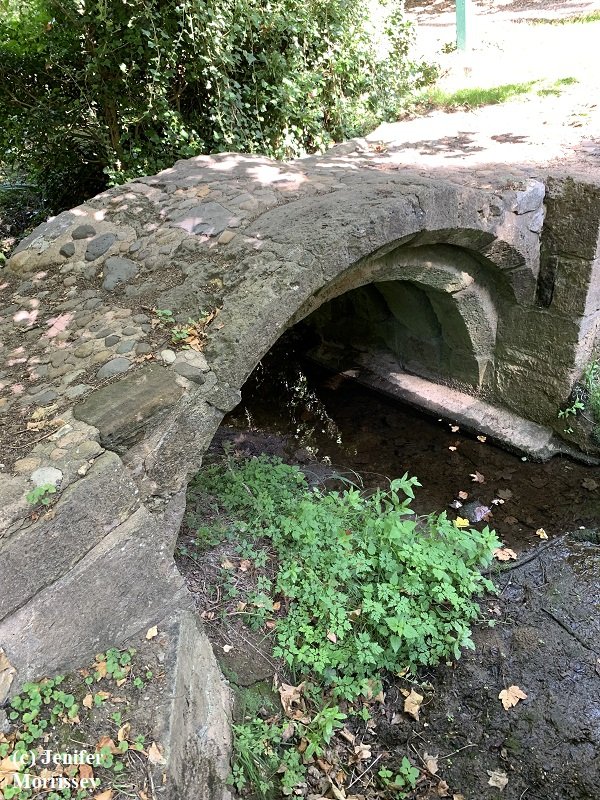
Utterby Packhorse Bridge, Lincolnshire, England
When I was a kid, my mother enjoyed jigsaw puzzles. She made them family activities by setting up a table in the middle of the living room around which we all could gather and help turn the chaos of pieces into the beautiful image on the front of the box. I learned early that shape and color and location meant something, that one puzzle piece on its own might be interesting but it was far more interesting in the context of the whole. I feel the same way about packhorse bridges in England. They are iconic items of beauty, but they are also puzzle pieces in the bigger picture of packhorse history there, a history that isn’t always visible. Since the Fell Pony played a role in that history, making the history more visible is always of interest to me! (Click here if you’d like to explore more about packhorse history in the home region of the Fell Pony.)

We saw a sign for Salter’s Lane but then couldn’t find it again when we had time for a photograph!
On a recent visit to Lincolnshire, England, I was pleased to find that a few packhorse bridges there have interpretive signs connecting them to the other puzzle pieces of packhorse history in the region. Packhorse routes developed long ago in Lincolnshire to take wool to market towns and to the port at Boston. They were also used to take salt inland. Trade in salt is dated to Roman times, and wool production peaked in the area in the 1300s when religious houses depended on it for income.

Remains of a stone causeway leading away from the church towards Utterby Bridge.
As we entered the Lincolnshire Wolds on our recent visit, which is an Area of Outstanding Natural Beauty, it wasn’t the landscape that had me nearly jumping out of the car seat. It was a road sign saying we were turning onto Salter’s Lane! My pre-trip research had indicated that such a road existed in the vicinity of one of the packhorse bridges, so I knew we were close to one. We didn’t stop for a picture though, because we were losing daylight and needed to get to our hotel. Alas, on two separate excursions over the next few days, we were unsuccessful finding the sign again. For now, a crude hand drawing is my only memento of this puzzle piece!

An historic stone causeway lies under the planted trees between the graveyard of the Church of St Andrew and the hedge along the road.
The bridge that was nearby to the sign was in the village of Utterby. Utterby Packhorse Bridge is situated next to a church, which is another important puzzle piece. The bridge’s interpretive sign says, “Just over a mile to the west of Utterby lies the site of a Gilbertine priory and lost village of North Ormsby which was established in 1184 and housed up to 50 canons and lay brothers and 100 nuns and lay sisters.” We went to where North Ormsby and the priory once stood, and indeed they are lost; there was no indication there at all of the former community or religious house’s existence.
The bridge’s interpretive sign continues, “The priory is known to have had a profitable share in the wool industry and was endowed with the Church of St. Andrew’s at Utterby. As the earliest surviving parts of St. Andrew’s also date from the early fourteenth century, it is likely that the building of the bridge was funded by the priory to improve access to the church by providing a crossing over Utterby Beck, also improving the packhorse route.”

The name ‘Porterfield’ indicates this was once an overnight spot for packhorse trains. This spot is about a quarter mile from Utterby Packhorse Bridge.
The construction of the bridge with its three stone arches also suggests it dates from the 1300s. We confirmed that tombstones in the graveyard date to at least the late 1600s; some were so badly eroded that it was hard to tell if they were older. The bridge is thought to lie on an historic saltway, which is its link to the Salter’s Lane puzzle piece. The saltway was in existence long before the church and the bridge.
Two other puzzle pieces are visible near the bridge: remains of stone causeways or human-built reinforced road surfaces. One influences the lay of the churchyard, running between the graveyard and the hedge at the road. The other runs from the churchyard outside the hedge almost to the bridge.
The final puzzle piece we found was also noted on the interpretive sign. A nearby property called Portersfield was once a stopover point for traders following the packhorse route. The name now makes that explanation obvious, but if I had seen it outside the context of the bridge, I wouldn’t have made the association!
I am grateful to the Lincolnshire County Council for their interest in the history of the packhorse bridges in the county and for the very informative interpretive signs that they’ve erected near them.
© Jenifer Morrissey, 2022